


- Dokdo in the East Sea
- Educational material
- High School Version
Dokdo in the East Sea


Table of Contents Open Contents
3. Dokdo and the East Sea
-
- Objectives
-
Explain Dokdo’s categorization as an island under international law.
Explain the contradiction in the name “Sea of Japan.”
-
- Critical Thinking
-
Dokdo, as an island, has several domains under international law. However, there is an area between Korea and Japan that has not been demarcated as an exclusive economic zone. How did this issue arise?
Dokdo’s Status Under International Law
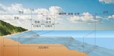
Domain conceptAirspace, Baseline, EEZ, International Waters
Territorial Land, Territorial Waters, 12 Nautical Miles, Contiguous Zone 12 Nautical Miles
200 Nautical Miles
Territorial Land, Territorial Waters, 12 Nautical Miles, Contiguous Zone 12 Nautical Miles
200 Nautical Miles

Both South Korea and Japan proclaimed 200 nautical miles of EEZ in 1996. Shortly after, it was discovered that certain EEZ areas were overlapping. As territorial disputes arose, it was clear that maritime boundaries had to be clarified between the two countries. Thus, a fisheries agreement was signed between South Korea and Japan. This agreement applies to the EEZ of both countries. The territorial waters around Dokdo are treated as Korean territory, therefore, they are not considered to be anintermediate zone of the EEZ. If the EEZ boundaries of the two countries are demarcated in the future, the provisional nature of the intermediate zone will be eliminated.
East Sea Misnomer

(Left) History of the Three Kingdoms Koguryo Section, (Right) Epitaph of King Gwanggaeto

After joining the United Nations in 1991, the South Korean government has claimed during the United Nations Conference on the Standardization of Geographical Names (UNCSGN) in 1992 that the sole nomination of the East Sea as the “Sea of Japan” was unreasonable. The international community has advised that when a naming dispute arises between two countries that both names are to be used until an agreement is reached. South Korea has claimed that both “East Sea” and “Sea of Japan” be used, but Japan has taken the position that any name other than “Sea of Japan” for the region is unacceptable.
The Trend Toward Using Both Names
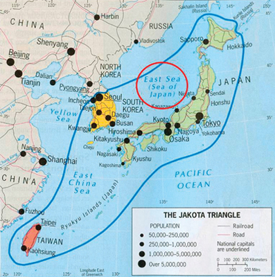
A map including both names(Source : Geography of the World, 4th ed.)

According to surveys conducted by the Japanese Ministry of Foreign Affairs and the Korean Ministry of Foreign Affairs and Trade, the use of both names has been steadily increasing: in 2000 (Japan) 2.8%, in 2005 (Japan) 10.8%, in 2007 (Korea) 23.8%, and in 2009 (Korea) 28.07%.
-
- Why “Sea of Japan” spread through the international community
-
In 1929, the International Hydrographic Organization (IHO)published the “Limits of Oceans and Seas,” and from this point “Sea of Japan” became accepted among the international community. Korea was a colony of Japan when the 1937 edition was published, and the third revision was published in 1953, during the Korean War. Thus, a request for a correction by the Korean government was difficult, if not impossible.
-
- Activity 1
-
Visit the Korea Hydrographic and Oceanographic Administration website and the East Sea Forum for more information about the East Sea. Watch the video entitled “East Sea” that was produced by the Northeast Asian History Foundation and discuss the naming dispute. [Dokdo Research Institute (
)> PR > Dokdo Videos > East Sea]
territorial waters
Coastal waters are regarded to be the sovereign territory of a state. The territory extends at most 12 nautical miles from the coastal baseline.
닫기
intermediate zone
As South Korea and Japan have had disagreements over the maritime boundaries of their respective EEZs, an area was designated as a zone in which fishermen from both countries can conduct fishing activities without the expressed permission.
닫기
United Nations Conference on the Standardization of Geographical Names (UNCSGN)
Held every five years, the United Nations Statistical Commission attempts to standardize the names of locations across languages, alphabets, and cultures. South Korea joined in 1979.
닫기
International Hydrographic Organization (IHO)
The IHO was founded in 1921 as the International Hydrographic Bureau, and the present name was adopted in 1970. This bureau was established as an effort to unify and standardize the numerous maritime procedures and charts of that time. A conference is held every five years in Monaco. South Korea joined the organization in 1957.
닫기


