


- Dokdo in the East Sea
- Educational material
- High School Version
Dokdo in the East Sea


Table of Contents Open Contents
2. Dokdo’s Geography and Ecology
-
- Objectives
-
Understand Dokdo’s formation and geographical characteristics
Understand Dokdo’s climate and ecosystem
-
- Critical Thinking
-
Dokdo was formed by underwater volcanic eruptions. A volcanic island is fundamentally different in its geological makeup than other islands. How do Dokdo’s geographical characteristics affect its climate and ecosystem? What types of unique life forms can be found on Dokdo?
Dokdo’s Formation

Seodo, Dongdo
Dokdo’s shape was carved by centuries of waves!
Dokdo’s base was formed by volcanic activity!
* The height of the mountain has been exaggerated and scaled up by a magnitude of four in relation to the width of the base.
Dokdo’s shape was carved by centuries of waves!
Dokdo’s base was formed by volcanic activity!
* The height of the mountain has been exaggerated and scaled up by a magnitude of four in relation to the width of the base.

Dokdo and Ulleungdo were formed by hardened lava from the seabed some 2,000 meters below sea level. Its base began to form about 4.6 million years, and the island broke the surface of the water roughly 2.7 million years ago. Originally a singular island, Dokdo began separating into two as it was eroded by water around 2.5 million years ago. It is believed to have taken its current shape some 2.1 million years ago as wind and water erosion continued to reshape the island.
Dokdo is the oldest of the volcanic islands of Korea. It was formed approximately 2.5 million years before Ulleungdo and about 2 million years prior to Jejudo.
-
- Activity 1
-
Compare Dokdo, Ulleungdo, and Jejudo, and confirm which island formation is the oldest.
Dokdo’s Geographical Characteristics
Dokdo is greatly influenced by the seas and feature a variety of marine topographical formations. Its bedrock consists of volcanic rocks. Thus, Dokdo’s geological characteristics consist of hardened volcanic ash (tuff) and alkaline volcanic rocks such as trachyte and basalt. Although they may look hardened, they are in fact extremely porous and easily worn or crumbled.
Dongdo’s summit is relatively flat compared to other areas, and is home to a lighthouse and a guard tower. The soil layer is about 20-30 centimeters deep and accommodates a variety of plant life. Dokdo’s coasts are mostly made up of steep marine cliffs around 30 meters in height, which are difficult for plant life to grow on. Conversely, Seodo’s summit consists of sharp ridges. However, the area southwest of the summit is relatively flat and features a soil layer capable of supporting plant life. A natural water reservoir is located in the northern area and is a source of drinking water.
Common geographical features found on Dokdo includecolumnar joints , fault lines, and wave-cut platformsalong the coastal terrain. In addition, severe wind erosion accounts for the wide distribution of panholesthroughout the island, visible in a variety of areas. Even today, Dokdo is continuously changing due to the effects of water erosion.
Dokdo’s Seabed

Dokdo’s SeabedSource : Korea Hydrographic and Oceanographic Administration
East Sea, Ulleungdo, Mt. Anyongbok, Dokdo
East Sea, Ulleungdo, Mt. Anyongbok, Dokdo

The entire seabed consists of various mountain ranges, and they are named after important figures in Dokdo’s history. Two underwater mountains roughly 15 kilometers and 55 kilometers southeast of Dokdo are Mt. Simheungtaek (second Dokdo underwater mountain) and Mt. Isabu (third Dokdo underwater mountain).
As Ulleungdo and Dokdo are part of the same mid-ocean ridge and composed of trachyte, they are considered to be qualitatively similar. On the other hand, Japan’s Oki Islands are composed of gneiss and are unrelated to volcanic activity, making them fundamentally different.
-
- Activity 2
-
Mt. Anyongbok can be seen in the same mid-ocean ridge as Ulleungdo and Dokdo. Locate Mt. Isabu and Mt. Simheungtaek in the same ridge.
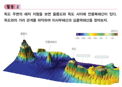 Ulleungdo, Mt. Anyongbok, Dokdo, ( ), ( )

Dokdo’s Climate

Currents Near Dokdo in Summer/Winter, August, FebruarySource : National Geographic Information Institute

Ulleungdo and Dokdo’s temperatures are around 12 degrees Celsius on average and relatively mild compared to similar regions. Ulleungdo and Dokdo have comparable average monthly temperatures with January and February being the coldest and August being the warmest.
Statistically, Ulleungdo and Dokdo see heavy rainfall during the summer months. The monsoon season brings rain in July, while the frequent typhoons in August and September are responsible for most of the rainfall.
Dokdo is affected by strong winds throughout the year. Depending upon the season, Dokdo encounters northeasterly and southwesterly winds. Wind speeds are high and turbulent through most of the year from January to August, and are moderate around October.
-
- Activity 3
-
Note the average monthly temperatures and precipitation for Ulleungdo and Dokdo in the following graph.
 Temperature, Precipitation, Average monthly temperatures, Average monthly precipitation
Ulleungdo climate (1981-2010)
Dokdo climate (2004-2010)

Dokdo’s Ecosystem
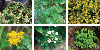
Ⓐ Tartarian aster (Aster spathulifolius Maxim), Ⓑ Giant knotweed (Reynoutria sachalinensis), Ⓒ Taito-gome (Sedum oryzifolium Makino), Ⓓ Stonecrop (Sedum takesimense), Ⓔ Spoonleaf yellow loosestrife (Lysimachia mauritiana Lam.), Ⓕ New Zealand Spinach (Tetragonia tetragonioides)Source : Cultural Heritage Administration

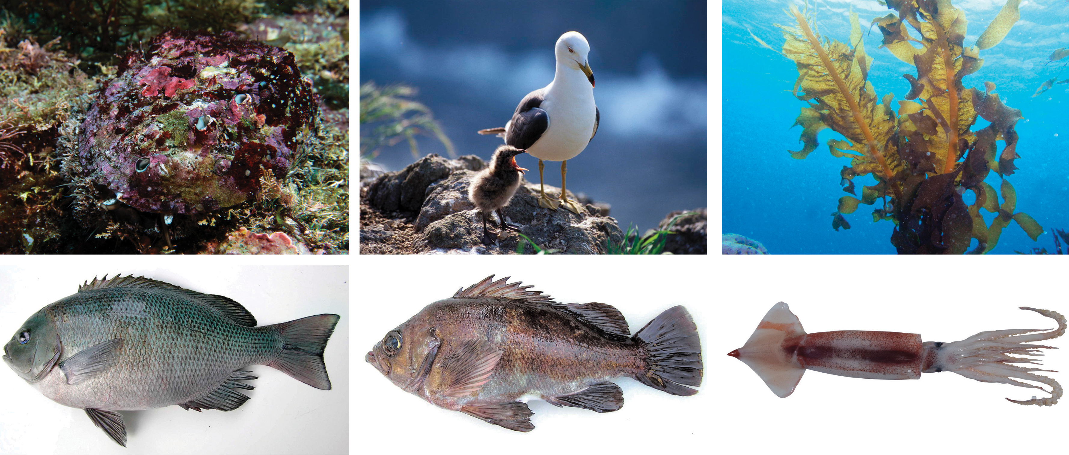
Dokdo’s Marine Life

Ⓐ Abalone, Ⓑ Black-tailed gull, Ⓒ Seaweed, Ⓓ Sea chubs, Ⓔ Rockfish, Ⓕ SquidSource : National Fisheries Research and Development Institute, Lee Dong-woo
Dokdo is home to about 93 different insect species, most of which are small with weak flight capabilities.
The island also serves as an important stopover point for migratory birds. Around 139 different bird species sightings have been confirmed. The main species include the black-tailed gull, petrel, shearwater, white wagtail, and island sparrow. Of these, the black-tailed gull, shearwater, and petrel are protected under the Dokdo Natural Protected Area ordinance.
About 370 different species of invertebrates and 223 species of algae are also found in and around Dokdo. In 2005, a marine flavobacterium called (Donghaeana Dokdonensis was discovered in Dokdo. Also known as “Donghae Dokdo,” it was introduced in a scientific journal in 2006.
marine cliffs
Marine cliff – Coastal cliffs that are formed by wind and water erosion

Marine cliff

닫기
columnar joints
Columnar joints - Parallel, prismatic columns that resulted from rapidly cooling lava, causing shrinkage cracks to form in a hexagonal pattern

Columnar joints

닫기
wave-cut platforms
Wave-cut platform - A flat bedrock formed by wind and water erosion
닫기
panholes
Panhole – A depressed, erosional feature found on flat or gently sloping rock

Panhole

닫기
mid-ocean ridge
A general term for an underwater mountain system that consists of various mountain ranges
닫기


