


- Dokdo in the East Sea
- Controversies surrounding Dokdo
- Dokdo! It can be seen from Ulleungdo
Dokdo in the East Sea


Table of Contents Open Contents
- Dokdo! It can be seen from Ulleungdo
- Overview: Background and Significance of the Dokdo Visibility Study
- Historical Meaning of “Dokdo’s Visibility from Ulleungdo”
-
Dokdo’s Visibility from Ulleungdo: Implications in International Law
- Ⅰ. Reasons Japanese Scholars Denied Dokdo’s Visibility from Ulleungdo
- Ⅱ. “Visibility of Dokdo from Ulleungdo” and Discovery in International Law
- Ⅲ. Dokdo’s Visibility from Ulleungdo and the Concept of Geographical Contiguity
- Ⅳ. Historical and Geographical Integrity and Territorial Sovereignty
- V. The Legal and Historical Unity of Ulleungdo and Dokdo
- The Meteorological Neaning of Dokdo’s Visibility from Ulleungdo
- Postscript after constant monitoring
1. The Unity of Ulleungdo and Dokdo in Literature
Prior to the sixth century, when Koreans began settling in Ulleungdo, Dokdo was already firmly in the mind of Koreans. In books such as Essentials of Governance (1808) and Revised Notes on Records, there is mention that both Ulleungdo and Dokdo are territories of the State of Usan.[note 118] From this, one may see that Ulleung and Dokdo were a single entity within the domain of the State of Usan. According to witness accounts by Hong Jae-hyeon, a settler in Ulleungdo in 1947,[note 119] it was common knowledge among Ulleungdo residents that Dokdo was a dependent island to Ulleungdo even during the late nineteenth century when Ulleungdo was repopulated or during Japan’s annexation of Dokdo in 1905-1906. It is possible that the fact of Dokdo’s visibility from Ulleungdo may have influenced their belief. In relation to this, the late legal scholar Jon Van Dyke commented as follows based upon the fact of Dokdo’s visibility from Ulleungdo.[note 120]
-
“The geographical location and the proximity to the mainland is an important factor to consider in a dispute surrounding a contested island. The fact that Dokdo is visible from Ulleungdo on clear days does indeed strengthen the link between the two islands and prove indirectly that the islands have been part of Korean sovereignty historically. In contrast, Dokdo is never visible from the Oki Islands of Japan. Its distance from the Oki Islands is 40 nautical miles farther apart than from Ulleungdo. This fact was important in the past when engine-powered boats were not available. … The close physical and historical link between Ulleungdo and Dokdo can be seen as evidence enough to back up Korea’s territorial claims on Dokdo.”[note 121]
2. The Unity of Ulleungdo and Dokdo in Japanese Texts
Also in Japanese texts can one find numerous references to the unity of Ulleungdo and Dokdo. Since the seventeenth century, when Dokdo began to appear in Japanese literature, Japanese recognized Dokdo as a dependent island to Ulleungdo. They called Ulleungdo as Takeshima (竹島) and Dokdo as Matsushima (松島). The reason the Japanese named Dokdo as Matsushima (meaning “the island of pine trees”) is not because the island has plentiful pine trees but because they wanted to contrast it with the island of bamboos (Takeshima).[note 122]During the seventeenth century, Japanese mentioned the islands in relation to fishery operations as follows: “Dokdo within Ulleungdo” (竹島之內松島), “Dokdo near Ulleungdo” (竹島近邊松島), and “the small island located near Ulleungdo” (竹島近所之小島).[note 123] Behind these expressions there lie the recognition that Dokdo is located close to Ulleungdo to a degree that it is visible from the latter island. Indeed, the Edo shogunate considered the geographical proximity in an important way when it notified the Joseon government in the first month of 1697 that it would ban Japanese fishermen from sailing to Ulleungdo.[note 124]
-
Takeshima [Ulleungdo] is so far from our country [Japan], but it is rather closer from your country [Joseon].
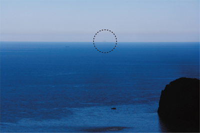
〈FIG 8〉 Dokdo Seen from the Seokpo Observatory, where the Japanese Naval Watchtower was Installed (August 6, 2008)

3. Japan’s Postwar Handling of Its Territories, and Legal and Geographical Integrity
After World War II, the Allied Powers, including the United States, relied on the principle of geographical contiguity when handling the territories of Japan. In the document entitled “U.S. Early Policy toward Japan after Surrender,” dated September 6, 1945, the United States government defined the Japanese territories based on the idea of “minor outlying islands,” a concept similar to geographical contiguity.
-
Japan's sovereignty will be limited to the islands of Honshu, Hokkaido, Kyushu, Shikoku and such minor outlying islands as may be determined, in accordance with the Cairo Declaration and other agreements to which the United States is or may be a party.
From this one can see that Japan’s territorial range has narrowed from “minor islands” to “minor outlying islands” and to “smaller adjacent islands.” As for the appearance of Tsushima in the document, Park Gwan-suk stated, “As Tsushima is closer to Korea than to Japan, the author of the document had to specifically indicate it because it did not belong to smaller adjacent islands.”[note 128] She added, “As Dokdo was neither a smaller adjacent island of Japan nor specifically indicated in the document as was Tsushima, it was excluded from Japanese territories.”[note 129]In “Basic Purposes of the Allied Occupation of Japan and the Manner in which They Are Carried out by the Allied Forces,” dated December 19, 1945, General Douglas MacArthur defined the territories of Japan as “Japanese sovereignty is limited to about one thousand smaller adjacent islands including the four main Japanese islands and Tsushima Island, and others,” similar to the Basic Initial Post-surrender Directive issued in November 1945.
In SCAPIN No. 677 “Governmental and Administrative Separation of Certain Outlying Areas from Japan,” dated January 29, 1946, the geographical definition was used. For the purpose of this directive, Japan is defined to include the four main islands of Japan (Hokkaido, Honshu, Kyushu, and Shikoku) and the approximately 1,000 smaller adjacent islands, including the Tsushima Islands and the Ryukyu Islands north of 30° North Latitude (excluding Kuchinoshima Island); and excluding Utsuryo (Ullung) Island, Liancourt Rocks (Take Island), and Quelpart (Saishu or Cheju) Island.
In “Basic Post-surrender Policy for Japan,” dated June 19, 1947, there is a reference related to Japan’s territories, “Japanese sovereignty is limited to the four main islands and small adjacent islands to be determined later.”[note 130] In the San Francisco Peace Treaty signed in 1951, there is no reference to “minor outlying islands” or “smaller adjacent islands,” but the treaty set forth the range of Japanese territories in the second provision on territories in detail.
In handling Japan’s territorial issues after the war, the Allied Powers used the concepts of “minor outlying islands” and “smaller adjacent islands.” But their precise meaning was ambiguous. Given the follow-up actions taken by the Allied Powers, however, outlying islands were taken to mean islands lying close geographically. Is Dokdo an outlying island to Japan? As is well known, Dokdo is closer from Ulleungdo by 70.1 kilometers than from the Oki Islands. From this, it is clear that Dokdo must have been treated by the Japanese government as a non-outlying island. If Dokdo was treated as an outlying island or an adjacent island, it must have been mentioned specifically, as was Tsushima. In sum, one can say that the postwar Allied Powers acknowledged that Dokdo formed an integral unity with Ulleungdo, not with the Oki Islands of Japan.
4. The Social and Cultural Unity between Ulleungdo and Dokdo

〈FIG 9〉 Dokdo Seen from a Farmhouse Garden with a uUtility Pole in the Foreground (Kakideung Village, Dodong, 11. 12, 2008)

According to data compiled by the Northeast Asian History Foundation, the best spots in Ulleungdo to see Dokdo are Kakideung village in Dodong-ri, including the KBS-TV signal tower, whose height ranges from 227 meters to 276 meters. The observers live in this area. They took photographs of Dokdo from many different spots. Of the Dokdo photographs taken by the observers are photographs with a persimmon tree in the background, while walking on a trail, and with a utility pole in the garden of a house in the background.[note 131] The locations in Ulleungdo from which one can see Dokdo include spots in the southeast such as Saegakdan (Sadong-ri), Naesujeon (Jeodong-ri), and Seokpo Village (Buk-myeon), as well as Dodong-ri.
This shows that the Ulleungdo residents have intimately known Dokdo in their everyday lives. Dokdo has been part of the residents’ lives, forming a sociocultural unity in a very familiar manner.[note 132]
- [note 118]
- In the “Book of Military Affairs” in Essentials of Governance is the statement, “According to geographical records, both Ulleungdo and Dokdo are part of State of Usan. Usando is what Japanese call Matsushima [Dokdo]” (輿地志云 鬱陵于山皆于山國地 于山則倭所謂松島也).
- [note 119]
- Statement by Ulleungdo settler Hong Jae-hyeon [Political Bureau, Ministry of Foreign Affairs (1955), Introduction to the Dokdo Issue, p. 36].
- [note 120]
- Van Dyke (2007), p. 193.
- [note 121]
- Van Dyke (2007), p. 194.
- [note 122]
- Sin Yong-ha (1999), “Proving Dokdo’s Sovereignty by Korea through Studies on Name Change in Dokdo and Ulleungdo,” Dokdo Studies Collection Vol. 6: Exploration of Dokdo Sovereignty Data, Dokdo Study Preservation Association, pp. 324-332.
- [note 123]
- Kawakami (1966), op. cit., p. 80.
- [note 124]
- For details on this point, see Hong Seong-geun (2009), op. cit., pp. 99-104.
- [note 125]
- Kuzuu Yoshihisa (1903), The Fishery Guide of Seas around Korea, Tokyo: Kokuryūkai Publishing, p. 123.
- [note 126]
- The passage in the Potsdam Declaration reads as follows: “The terms of the Cairo Declaration shall be carried out and Japanese sovereignty shall be limited to the islands of Honshu, Hokkaido, Kyushu, Shikoku and such minor islands as we determine.”
- [note 127]
- Park Gwan-suk (1968), “A Study on the Legal Status of Dokdo,” Ph.D. Dissertation, Yonsei University, pp. 60-61.
- [note 128]
- Park Gwan-suk (1968), ibid., p. 62.
- [note 129]
- Park Gwan-suk (1968), ibid., p. 62.
- [note 130]
- Park Gwan-sook (1968), Ibid, p. 68.
- [note 131]
- Northeast Asian History Foundation (2009), Photobook of Dokdo Seen from Ulleungdo.
- [note 132]
- There are many stories about Dokdo handed down by generations of Ulleungdo residents. Ulleung County Government (2007), Ulleung County Journal, pp. 796 and 843.
[note 118]
In the “Book of Military Affairs” in Essentials of Governance is the statement, “According to geographical records, both Ulleungdo and Dokdo are part of State of Usan. Usando is what Japanese call Matsushima [Dokdo]” (輿地志云 鬱陵于山皆于山國地 于山則倭所謂松島也).
닫기
[note 119]
Statement by Ulleungdo settler Hong Jae-hyeon [Political Bureau, Ministry of Foreign Affairs (1955), Introduction to the Dokdo Issue, p. 36].
닫기
[note 120]
Van Dyke (2007), p. 193.
닫기
[note 121]
Van Dyke (2007), p. 194.
닫기
[note 122]
Sin Yong-ha (1999), “Proving Dokdo’s Sovereignty by Korea through Studies on Name Change in Dokdo and Ulleungdo,” Dokdo Studies Collection Vol. 6: Exploration of Dokdo Sovereignty Data, Dokdo Study Preservation Association, pp. 324-332.
닫기
[note 123]
Kawakami (1966), op. cit., p. 80.
닫기
[note 124]
For details on this point, see Hong Seong-geun (2009), op. cit., pp. 99-104.
닫기
[note 125]
Kuzuu Yoshihisa (1903), The Fishery Guide of Seas around Korea, Tokyo: Kokuryūkai Publishing, p. 123.
닫기
[note 126]
The passage in the Potsdam Declaration reads as follows: “The terms of the Cairo Declaration shall be carried out and Japanese sovereignty shall be limited to the islands of Honshu, Hokkaido, Kyushu, Shikoku and such minor islands as we determine.”
닫기
[note 127]
Park Gwan-suk (1968), “A Study on the Legal Status of Dokdo,” Ph.D. Dissertation, Yonsei University, pp. 60-61.
닫기
[note 128]
Park Gwan-suk (1968), ibid., p. 62.
닫기
[note 129]
Park Gwan-suk (1968), ibid., p. 62.
닫기
[note 130]
Park Gwan-sook (1968), Ibid, p. 68.
닫기
[note 131]
Northeast Asian History Foundation (2009), Photobook of Dokdo Seen from Ulleungdo.
닫기
[note 132]
There are many stories about Dokdo handed down by generations of Ulleungdo residents. Ulleung County Government (2007), Ulleung County Journal, pp. 796 and 843.
닫기


