


- Dokdo in the East Sea
- Dokdo in History
- Old Maps Related to Dokdo and the East Sea
Dokdo in the East Sea


| Map Name | Gangleung | ||
|---|---|---|---|
| Publisher | Le Service Géographieque de L''Armée) | Place | France |
| Date | 1904 | size | 67×54 cm |
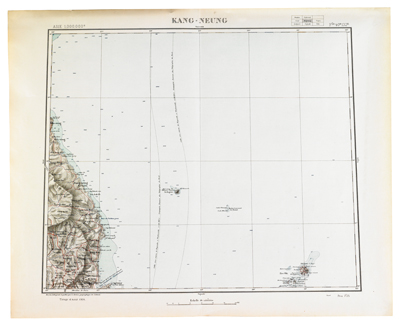

Produced at a scale of 1:1,000,000, the French Institut Géographique Nationale (formerly Service Géographieque de L''Armée) first compiled this map in 1898 for military and commercial purposes. The geographic locations of Korea in in the map are Seoul, Jeju, and Vladivostok, in addition to Gangneung. The map issued in 1904 is not the result of a new survey but rather is a compilation of existing data and maps. It marks the underwater cable between Nagasaki and Vladivostok as a line. Ulleungdo is marked as Oul-neug-To (Matsou Shima) and Ile Dagelet, and a rock east of Ulleungdo is identified as R. Boussole. Dokdo is marked as Roches Liancourt and as Ile Hornet, and the west and east islets are identified as Scala Olioutsa and Scala Manelai, respectively.
Edited by the Northeast Asian History Foundation
Edited by the Northeast Asian History Foundation