


- Dokdo in the East Sea
- Dokdo in History
- Old Maps Related to Dokdo and the East Sea
Dokdo in the East Sea


| Map Name | Complete Map of Shimane Prefecture | ||
|---|---|---|---|
| Publisher | Andō Rikinosuke (安藤力之助) | Place | Japan |
| Date | 1929 | size | 54×40 cm |
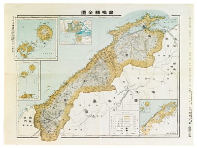

Drawn at a scale of 1:400,000, this map is one of the 56 chapters of the “Greater Japan Prefecture Map” (大日本分縣地圖). The first edition was published in Tokyo in 1908, and was followed by a revised edition in 1929. In this image are insert maps, such as those for Matsue, the Shimane Prefecture milepost, and the Oki Islands. Although the Japanese government illegally annexed Dokdo into Shimane Prefecture in 1905, the map does not show this in the Oki Islands insert.
Edited by the Northeast Asian History Foundation
Edited by the Northeast Asian History Foundation