


- Dokdo in the East Sea
- Controversies surrounding Dokdo
- Dokdo! It can be seen from Ulleungdo
Dokdo in the East Sea


Table of Contents Open Contents
- Dokdo! It can be seen from Ulleungdo
- Overview: Background and Significance of the Dokdo Visibility Study
- Historical Meaning of “Dokdo’s Visibility from Ulleungdo”
-
Dokdo’s Visibility from Ulleungdo: Implications in International Law
- Ⅰ. Reasons Japanese Scholars Denied Dokdo’s Visibility from Ulleungdo
- Ⅱ. “Visibility of Dokdo from Ulleungdo” and Discovery in International Law
- Ⅲ. Dokdo’s Visibility from Ulleungdo and the Concept of Geographical Contiguity
- Ⅳ. Historical and Geographical Integrity and Territorial Sovereignty
- V. The Legal and Historical Unity of Ulleungdo and Dokdo
- The Meteorological Neaning of Dokdo’s Visibility from Ulleungdo
- Postscript after constant monitoring
The young men and women in Ulleungdo have had had an intimate relationship in one way or another with Dokdo during their lives. The author, too, has had the same relationship with Dokdo for more than 20 years. Since about 20 years ago, I have gone up and down the mountains with my backpack filled with dirt as part of a campaign to plant trees in Ulleungdo as a member of the island’s mountain hiking club. Often times I would climb up to the foot of Tanggeon Peak and hammered in a hook with the Taegeuk Flag attached to it. In addition, I did ridge climbing to collect garbage and conduct a vegetation survey in the Cheonjang Cave on East Islet and made an investigative trip for spindle trees, a tree protected by the North Gyeongsang Provincial Government.

 Hong Seong-geun then requested a survey of Dokdo’s visibility days. With the support of the Ulleungdo Mountain Hiking Club, I set out to conduct the investigation for 18 months from July 1, 2008, to December 31, 2009.
During the survey period, we received numerous sightings of Dokdo by telephone from hiking club members who went into the mountains on weekends. There were several occasions when the sightings were made at a low height, with visibility at the mid-range around 700 meters blocked by frequent fog. On rare occasions, there were reports that Dokdo was visible at the top of the peak.
The most important reason that the author could conduct the visibility study with confidence was that it took only five minutes on foot from where I lived to see the island. In addition, the desire to confirm through my own observations the rumor that Dokdo was visible for about 50 days a year from Ulleungdo was also a factor in accepting the offer.
 Now that I have finished the 18-month project and published the findings with comments by professionals in several fields, I feel pride as the leader of the project. I am reminded of the time in the beginning when I met Hong Seong-geun and others to discuss where we should go from there. At that time, I really had no idea what to do.
All the experience and knowledge I have gained about mountain hiking, all the equipment that I purchased for hiking, the GPS device, the camera, all the programs related to how to use GPS that I have learned so far; Air Force officers that I befriended while bivouacking at Maljandeung; hiking equipment at the mountain hiking club; Park Seung-gi of the Kolon Hiking School who taught me how to draw maps with coordinate data …. It is doubtful whether the project could have been completed successfully without all these people and devices. I express my gratitude to everyone who helped us for the duration of the project.
 I am reminded of an episode that I experienced during the 18-month visibility study that I have not been able to tell anyone. I spent a night at the home of Lee Deok-jun, of Seokpo, because of heavy drInking with him after installing the TV camera. Unfortunately, however, the TV camera broke down without taking a single picture of Dokdo due to overvoltage during severe lightning in less than a month, even though I had installed a UPS device and ground rod.
Other episodes include one in which I was caught in a drInking party on the night to deliver the observation journal to the Maljandeung site, which was at 970 meters, and smashed my car into a rice paddy after slipping on an icy road on the way home from Seokpo. On that night I had to walk all the way home to Jeodong-ri. There were days when I could see Dokdo for about five minutes after checking more than 20 times during the day.
There were numerous days in which I ran breathlessly to the Naesujeon Observatory in vain after having seen Dokdo from the KBS signal tower. Although I knew full well there was nothing I could do about it, I was so often frustrated back then.
 After seeing the cloud distribution map on the Korea Meteorological Administration website, I took a trip to the Seokpo Observatory in the early hours of the day with ham radio hobbyists to see the sunrise from Dokdo and take photographs and videos of it.
Sometimes I talked loudly with amateur ham radio operators on the other side of the earth that Dokdo is visible from here. On my way home, I saw the Baekdu mountain range on the east coast of the mainland from the western coast of Ulleungdo. Whenever I went to Dokdo, I spent two hours on the boat’s deck and realized that Ulleungdo’s main island is no longer visible as it is blocked by East Islet by the time the boat approaches the West Islet pier. For the whole 18 months, I looked out at the horizon every morning as soon as I opened my eyes. A finding from the investigation was that one can see Dokdo often even on cloudy, rainy, or snowy days in addition to clear days, which is quite different from the generally accepted notion. It is natural to see the island on clear days. But the reason the island is sometimes visible in bad weather may be due to the fact that visibility is also affected by the weather at sea. On the day when I could see Dokdo under snowy conditions in Ulleungdo, it was sunny on the side of Dokdo over the horizon.

 As described above, I checked more than 20 times during the day to see if Dokdo was visible because a cold wind was blowing from the north (called “Sat-baram” in Ulleungdo) and I knew from experience that one likely could see the island under this condition. Soon my hunch would be proven by the real view of Dokdo. When high pressure fronts from the continent in the north move south, I knew it would be a day to see Dokdo.
Another achievement from the investigation was that we could record precisely the observation points in Dokdo in the digital topographical map of Korea using the GPS devices. Except for the points above 500 meters, most observation points were from heights of 133 meters or higher. All these points were inhabited from olden times. One can always find houses and farmlands in these points. The residents in these areas could see Dokdo whenever they turned their head while working on the farms. In other words, for those living in Ulleungdo, Dokdo has been intimately connected with their lives since the first inhabitants arrived.
They could see Dokdo while working the farms, walking on the trail, or looking for wild greens. I do not know why Japanese nonetheless claim Dokdo is not visible from Ulleungdo. For the entire period of 18 months, I saw Dokdo numerous times.
As I write this, I have seen the island all day from the early morning.
〈FIG 1〉 A Scene of Ridge Climbing in Dokdo (Cheonjang Cave, West Islet, 2010, 6. 7)

During the survey period, we received numerous sightings of Dokdo by telephone from hiking club members who went into the mountains on weekends. There were several occasions when the sightings were made at a low height, with visibility at the mid-range around 700 meters blocked by frequent fog. On rare occasions, there were reports that Dokdo was visible at the top of the peak.
The most important reason that the author could conduct the visibility study with confidence was that it took only five minutes on foot from where I lived to see the island. In addition, the desire to confirm through my own observations the rumor that Dokdo was visible for about 50 days a year from Ulleungdo was also a factor in accepting the offer.
〈FIG 2〉Dokdo(Dongdo) Seen from the Ulleungdo(2008. 11. 20)

All the experience and knowledge I have gained about mountain hiking, all the equipment that I purchased for hiking, the GPS device, the camera, all the programs related to how to use GPS that I have learned so far; Air Force officers that I befriended while bivouacking at Maljandeung; hiking equipment at the mountain hiking club; Park Seung-gi of the Kolon Hiking School who taught me how to draw maps with coordinate data …. It is doubtful whether the project could have been completed successfully without all these people and devices. I express my gratitude to everyone who helped us for the duration of the project.
〈FIG 3〉The closed-circuit TV camera and computer

Other episodes include one in which I was caught in a drInking party on the night to deliver the observation journal to the Maljandeung site, which was at 970 meters, and smashed my car into a rice paddy after slipping on an icy road on the way home from Seokpo. On that night I had to walk all the way home to Jeodong-ri. There were days when I could see Dokdo for about five minutes after checking more than 20 times during the day.
There were numerous days in which I ran breathlessly to the Naesujeon Observatory in vain after having seen Dokdo from the KBS signal tower. Although I knew full well there was nothing I could do about it, I was so often frustrated back then.
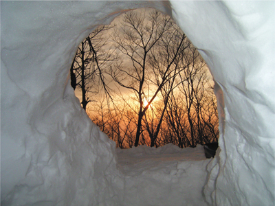
〈FIG 4〉Sunrise in winter seen from a cave in Ulleungdo

Sometimes I talked loudly with amateur ham radio operators on the other side of the earth that Dokdo is visible from here. On my way home, I saw the Baekdu mountain range on the east coast of the mainland from the western coast of Ulleungdo. Whenever I went to Dokdo, I spent two hours on the boat’s deck and realized that Ulleungdo’s main island is no longer visible as it is blocked by East Islet by the time the boat approaches the West Islet pier. For the whole 18 months, I looked out at the horizon every morning as soon as I opened my eyes. A finding from the investigation was that one can see Dokdo often even on cloudy, rainy, or snowy days in addition to clear days, which is quite different from the generally accepted notion. It is natural to see the island on clear days. But the reason the island is sometimes visible in bad weather may be due to the fact that visibility is also affected by the weather at sea. On the day when I could see Dokdo under snowy conditions in Ulleungdo, it was sunny on the side of Dokdo over the horizon.
〈FIG 5〉The Korean Peninsula Seen from the Seokpo Observatory, Ulleungdo (August 6, 2008)

〈FIG 6〉Dokdo Seen from Kakideung, Dodong-ri, Ulleungdo (October 12, 2008)

Another achievement from the investigation was that we could record precisely the observation points in Dokdo in the digital topographical map of Korea using the GPS devices. Except for the points above 500 meters, most observation points were from heights of 133 meters or higher. All these points were inhabited from olden times. One can always find houses and farmlands in these points. The residents in these areas could see Dokdo whenever they turned their head while working on the farms. In other words, for those living in Ulleungdo, Dokdo has been intimately connected with their lives since the first inhabitants arrived.
They could see Dokdo while working the farms, walking on the trail, or looking for wild greens. I do not know why Japanese nonetheless claim Dokdo is not visible from Ulleungdo. For the entire period of 18 months, I saw Dokdo numerous times.
As I write this, I have seen the island all day from the early morning.


