


- Dokdo in the East Sea
- Educational material
- Junior High School Version
Dokdo in the East Sea


Table of Contents Open Contents
- Dokdo: Korean Territory
- Dokdo: Keeper of the East Sea!
- Ulleungdo and Dokdo: We’re Siblings!
- Dokdo’s Been Korean Land Since the Three Kingdoms Period!
- Dokdo’s Been Korean Land in the Modern Era!
- Dokdo Appears Even on Old Maps!
- Mission: Protect Dokdo!
- Others Have Known, Too ... That Dokdo Is Korean Land!
- Dokdo Is Korean Land Even on Old Japanese Maps!
- Japan’s Claims to Dokdo Are False!
5 Chapter Reference
1 Dokdo in Old Maps
△ “Map of the Eight Provinces,” in Map of the East (八道總圖 『東纜圖』)Sixteenth century, woodblock print, 29.5×34.0cm
This is a condensed map of Korea that shows major mountains, rivers, islands, and provinces.
Ulleungdo and Usando also are identified.
This is a condensed map of Korea that shows major mountains, rivers, islands, and provinces.
Ulleungdo and Usando also are identified.


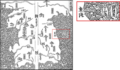
△ “Complete Nautical Map”Mid-nineteenth century, woodblock print, 28.5×34cm,
Dokdo’s old name of “Usando” is clearly legible inside a black circle.
Dokdo’s old name of “Usando” is clearly legible inside a black circle.

However, Usando was incorrectly located to the west of Ulleungdo throughout the seventeenthcentury. “Map of the Eight Provinces” and the map “Gangwon-do” both in New and Expanded Complete Conspectus of the Territory of the Eastern Country, a compilation of early Joseon-period geographical records, appear to be the principal sources of the incorrect location. The publication and distribution of this gazetteer greatly influenced other maps. “Map of the Eight Provinces” shows Ulleungdo and Dokdo as oblong shapes, and many maps published thereafter illustrate the islands in much the same manner.
An Yong-bok’s efforts resulted in a more precise geographical knowledge of Dokdo. Jeong Sang-gi’s “Complete Map of the Eastern Country” in the eighteenth century, and other maps influenced by it, correctly illustrated Usando (Dokdo) as east of Ulleungdo, thus enhancing that period’s geographical precision. In addition, the shape of both islands are more precise, as well, and resemble modern maps.
“Complete Nautical Map,” which was compiled in the late nineteenth century, also shows Ulleungdo and Usando (Dokdo), and includes historical records about Korea and its islands.


