


- Dokdo in the East Sea
- Controversies surrounding Dokdo
- Dokdo! It can be seen from Ulleungdo
Dokdo in the East Sea


Table of Contents Open Contents
- Dokdo! It can be seen from Ulleungdo
- Overview: Background and Significance of the Dokdo Visibility Study
- Historical Meaning of “Dokdo’s Visibility from Ulleungdo”
-
Dokdo’s Visibility from Ulleungdo: Implications in International Law
- Ⅰ. Reasons Japanese Scholars Denied Dokdo’s Visibility from Ulleungdo
- Ⅱ. “Visibility of Dokdo from Ulleungdo” and Discovery in International Law
- Ⅲ. Dokdo’s Visibility from Ulleungdo and the Concept of Geographical Contiguity
- Ⅳ. Historical and Geographical Integrity and Territorial Sovereignty
- V. The Legal and Historical Unity of Ulleungdo and Dokdo
- The Meteorological Neaning of Dokdo’s Visibility from Ulleungdo
- Postscript after constant monitoring
Lee Deok-jun, an Ulleungdo resident, told us a story about Dokdo when we visited his house in July 2010 on a field trip. While living in Ulleungdo’s Seokpo for 12 years, Lee even opened a window to the side facing Dokdo. According to his account, one could see from Seokpo the grand view of the sunrise from behind Dokdo in mid-November. I searched the Internet for sunrises in Dokdo and found a blog posting on the exact sunrise time in Dokdo[note 149] According to the posting, one can see the sun rise from Dokdo at the Dokdo Observatory in Ulleungdo between 7:29 a.m. and 7:31 a.m. from Christmas Day to New Year’s Day. But the author of the posting added the disclaimer that this may not be scientifically precise.

 Is it true that one can see the Dokdo sunrise from Seokpo during November? If it is, we could take photographs of the great moment on a clear day. I named this moment “Dokdo Glory,” the sunrise in Dokdo seen from Seokpo, Ulleungdo.
I did Internet searches on the dates of “Dokdo Glory,” when the island appears most spectacular. Even though the real moment is very short, I would like to call the complete time interval in which the sun rises near Dokdo as Dokdo Glory.
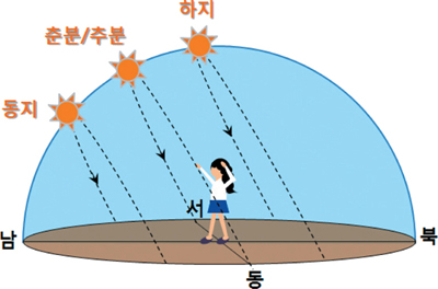
The sun rises from the east, passes through the meridian passage altitude, and sets to the west. The sun’s path from east to west is longest in June, around the time of the summer solstice, and is shortest in December, during the winter solstice〈FIG 32〉.
 The reason for the gradual change in the sun’s path is because of the earth’s revolution and rotation. Let us follow the sun’s path that changes little by little every day.
To observe the sun, one must be able to find the correct location of the sun. Just as we indicate a point on the map by means of latitude and longitude, the coordinates of stars can be indicated by declination and right ascension. In other words, declination and right ascension are latitude and longitude in the sky.
The direction of the earth’s rotational axis is almost fixed. As the equatorial plane is perpendicular to this axis, it can be said that the plane is also almost fixed. Therefore, the equatorial plane can be the reference surface of a coordinate system that does not depend upon the observer’s location. The angular distance of a point north or south of the celestial equator, which is not subject to the earth’s rotation, is defined as declination. Right ascension is the angular distance measured eastward along the celestial equator from the vernal equinox (or spring equinox) to the hour circle of the point in question.[note 150] For how to calculate the sun’s location, see [note 151]
To change the sun’s location (declination and right ascension) from the viewpoint of the observer, one must use the horizontal plane as the base level. The base level of this coordinate system passes through the observer and makes contact with the earth. An imaginary point directly above the observer on the imaginary celestial sphere is called zenith, and the big circle passing through this zenith is called verticals. Just like declination and right ascension above, the two coordinates that can reveal the sun’s location are altitude and azimuth. Altitude is an angle measured between the horizon and the celestial sphere along the verticals. Azimuth meanwhile is the distance from a fixed direction to the celestial sphere’s verticals. Depending upon the situation, different fixed directions are used to measure the azimuth. The sun’s location as expressed by the azimuth and altitude may differ at the same time depending upon the location of the observer.
Let us assume that the observer is in Seokpo Village[note 152]and enter the coordinates of the place in the formula to come up with the sun’s altitude and azimuth.
The altitude of the sun when it is at the highest point of the day is called the meridian altitude. Of all the different points of the sun every hour, the meridian altitude at which Dokdo is visible from Seokpo can be calculated as follows.
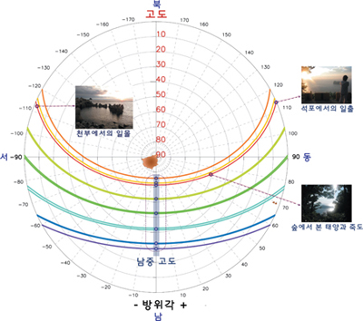 Following the formula above, the sun’s path seen in Seokpo is as follows. From January to December, the sun follows the longest path in June and the shortest path in December (in 〈FIG 33〉the path is depicted in orange and purple, respectively). The red-colored line here indicates the sun’s path on July 29, 2010, when the author visited Ulleungdo, as shown in the photographs taken throughout the day.
The sunrise from Seokpo was seen on the left side of Jukdo about two kilometers away. Before the sun reached the meridian altitude, the altitude was as high as 50 degrees. The sun came out from the Yetgil tracking course[note 153] together with Jukdo. In November, the sun rises on the right side of Jukdo, with the sunrise occurring near Dokdo, about 90 kilometers from Seokpo.
 Following the eyewitness account by Seokpo resident Lee Deok-jun, we calculated the number of days in which the sun falls on the boat going to Dokdo from Seokpo.
When exactly in November can we see Dokdo Glory and at what latitude does the sun passes through Seokpo? How long can we see Dokdo Glory? Further, there would be a time at which the sun passes through exactly the same point in January or February when it moves north from the winter solstice. If the weather permits, we could see Dokdo Glory in January or February, too. We also examined the time of sunrise in November and in January-February when Ulleungdo, Dokdo, and the sun align in a straight line.
In the previous section, the sun’s location at sunrise when the altitude is 0 in Seokpo is indicated in 〈FIG 35〉 and 〈FIG 36〉 following the formula to calculate altitude and azimuth. The azimuth between Seokpo and Dokdo is 110° 33′37″.1519 (based on true north 0°)[note 154] Based on true south as 0 degrees, the figure was indicated with the sun’s location in November and January at sunrise. We determined the exact time that the location of Dokdo and the sun correspond. Dokdo Glory can be seen in November and in January-February, while the “Golden Sunrise” in which Ulleungdo, Dokdo, and the sun align in a straight line can be expected on November 6-10 and February 1-5.
We visited Seokpo again on November 18, 2010, to see "Dokdo Glory", but the rising sun was barely visible because of low clouds. We were unable to see Dokdo, too, due to the thick fog on the sea. Without the sea fog and low clouds, we could have seen Dokdo Glory, in which Dokdo appears with the sun in between Jukdo and the sun.
 Given the procession of the Sun that changes its location relative to the earth slightly every year, as well as the atmospheric refraction and the visible range of Dokdo [the azimuth between the Dokdo (Seodo) peak and Seokpo only], one needs to allow for one or two days from the time of the “Golden Sunrise” in which Ulleungdo-Dokdo-sun aligns in a straight line. During this short time period, one may see the spectacular "Dokdo Glory" sunrise if the weather permits.
It is natural that Dokdo is visible from Ulleungdo. It is more clearly visible when cold, clean air moves from the northeast, sweeping the humid air away from the sea.
We found that at around the time of the winter solstice in November and early February that one can see the spectacular Dokdo Glory in which the sun rises near Dokdo so that one can witness both the island and sunrise at the same time. Sometimes one can also see the “Golden Sunrise” in which Ulleungdo, Dokdo, and the sun align in a straight line.
Let us now go on a trip to Ulleungdo to discover Dokdo on the sea!
〈FIG 31〉 At around 7am. on November 18, 2010, Dokdo could not be seen due to the sea fog and low-hanging clouds. In the direction in which the binocular points is Dokdo hidden between the right side of Jukdo and the sun.

I did Internet searches on the dates of “Dokdo Glory,” when the island appears most spectacular. Even though the real moment is very short, I would like to call the complete time interval in which the sun rises near Dokdo as Dokdo Glory.
1) The Sun’s Location from Seokpo, Ulleungdo
The sun rises from the east, passes through the meridian passage altitude, and sets to the west. The sun’s path from east to west is longest in June, around the time of the summer solstice, and is shortest in December, during the winter solstice〈FIG 32〉.
〈FIG 32〉The sun’s daily path from east to west is shown in dotted lines. The pathway is shortest on the winter solstice day and longest on the summer solstice day.

To observe the sun, one must be able to find the correct location of the sun. Just as we indicate a point on the map by means of latitude and longitude, the coordinates of stars can be indicated by declination and right ascension. In other words, declination and right ascension are latitude and longitude in the sky.
The direction of the earth’s rotational axis is almost fixed. As the equatorial plane is perpendicular to this axis, it can be said that the plane is also almost fixed. Therefore, the equatorial plane can be the reference surface of a coordinate system that does not depend upon the observer’s location. The angular distance of a point north or south of the celestial equator, which is not subject to the earth’s rotation, is defined as declination. Right ascension is the angular distance measured eastward along the celestial equator from the vernal equinox (or spring equinox) to the hour circle of the point in question.[note 150] For how to calculate the sun’s location, see [note 151]
|
(1) Calculating the number of days in a year
The number of days in a year can be calculated by adding one day on January 1, 32 days on February 1, and so on until 365 days on December 31 (366 days in leap years). |
|
(2) Day angle
Г=2π×(Number of Days-1)/365 |
|
(3) Solar right ascension
Right ascension is expressed in hours by dividing 360 degrees into 24. The base point of the right ascension is the spring equinox point. w=15×[12-(Hour+Minute/60)] |
|
(4) Solar declination
Similar to the latitude, the declination is indicated as angles from the celestial equator. North of the celestial equator ranges from 0 to 90 degrees and south ranges from 0 to -90 degrees. δ=cos-1[(0.006918-0.399912cosГ+0.070257sinГ -0.006758cos2Г+0.000907sin2Г -0.002697cos3Г+0.00148sin3Г)] |
Let us assume that the observer is in Seokpo Village[note 152]and enter the coordinates of the place in the formula to come up with the sun’s altitude and azimuth.
|
(5) Latitude of Seokpo Village, Ulleungdo
Δ=37° 32′.116 |
〈Table 13〉 Solar Altitude at Meridian Passage for 365 Days (the dates of spring equinox, summer solstice, autumnal equinox, and winter solstice are based on those of 2011)
| January | February | March | April | May | June | July | August | September | October | November | December | |
| 1 | 29.4 | 34.3 | 44.6 | 56.3 | 67.3 | 74.3 | 75.6 | 70.7 | 61.4 | 49.6 | 38.6 | 30.8 |
| 2 | 29.5 | 34.6 | 45.0 | 56.7 | 67.6 | 74.4 | 75.6 | 70.4 | 61.0 | 49.2 | 38.3 | 30.6 |
| 3 | 29.6 | 34.9 | 45.3 | 57.1 | 67.9 | 74.6 | 75.5 | 70.2 | 60.7 | 48.8 | 38.0 | 30.5 |
| 4 | 29.7 | 35.1 | 45.7 | 57.5 | 68.2 | 74.7 | 75.4 | 69.9 | 60.3 | 48.4 | 37.6 | 30.3 |
| 5 | 29.8 | 35.4 | 46.1 | 57.9 | 68.5 | 74.8 | 75.3 | 69.7 | 59.9 | 48.0 | 37.3 | 30.2 |
| 6 | 29.9 | 35.7 | 46.5 | 58.2 | 68.8 | 74.9 | 75.2 | 69.4 | 59.6 | 47.7 | 37.0 | 30.1 |
| 7 | 30.0 | 36.0 | 46.9 | 58.6 | 69.1 | 75.0 | 75.2 | 69.1 | 59.2 | 47.3 | 36.7 | 29.9 |
| 8 | 30.1 | 36.3 | 47.3 | 59.0 | 69.3 | 75.1 | 75.0 | 68.8 | 58.8 | 46.9 | 36.4 | 29.8 |
| 9 | 30.3 | 36.6 | 47.7 | 59.4 | 69.6 | 75.2 | 74.9 | 68.6 | 58.5 | 46.5 | 36.1 | 29.7 |
| 10 | 30.4 | 36.9 | 48.1 | 59.7 | 69.9 | 75.3 | 74.8 | 68.3 | 58.1 | 46.1 | 35.8 | 29.6 |
| 11 | 30.5 | 37.2 | 48.5 | 60.1 | 70.1 | 75.4 | 74.7 | 68.0 | 57.7 | 45.8 | 35.5 | 29.5 |
| 12 | 30.7 | 37.5 | 48.8 | 60.5 | 70.4 | 75.5 | 74.6 | 67.7 | 57.3 | 45.4 | 35.2 | 29.4 |
| 13 | 30.9 | 37.9 | 49.2 | 60.9 | 70.6 | 75.6 | 74.4 | 67.4 | 57.0 | 45.0 | 35.0 | 29.4 |
| 14 | 31.0 | 38.2 | 49.6 | 61.2 | 70.9 | 75.6 | 74.3 | 67.1 | 56.6 | 44.6 | 34.7 | 29.3 |
| 15 | 31.2 | 38.5 | 50.0 | 61.6 | 71.1 | 75.7 | 74.1 | 66.8 | 56.2 | 44.2 | 34.4 | 29.2 |
| 16 | 31.4 | 38.8 | 50.4 | 61.9 | 71.4 | 75.8 | 74.0 | 66.5 | 55.8 | 43.9 | 34.2 | 29.2 |
| 17 | 31.6 | 39.2 | 50.8 | 62.3 | 71.6 | 75.8 | 73.8 | 66.1 | 55.4 | 43.5 | 33.9 | 29.1 |
| 18 | 31.8 | 39.5 | 51.2 | 62.7 | 71.8 | 75.8 | 73.6 | 65.8 | 55.0 | 43.1 | 33.7 | 29.1 |
| 19 | 32.0 | 39.9 | 51.6 | 63.0 | 72.1 | 75.9 | 73.5 | 65.5 | 54.7 | 42.8 | 33.4 | 29.1 |
| 20 | 32.2 | 40.2 | 52.0 | 63.4 | 72.3 | 75.9 | 73.3 | 65.2 | 54.3 | 42.4 | 33.2 | 29.1 |
| 21 | 32.4 | 40.6 | 52.4 spring equinox | 63.7 | 72.5 | 75.9 | 73.1 | 64.8 | 53.9 | 42.0 | 32.9 | 29.0 |
| 22 | 32.6 | 40.9 | 52.8 | 64.0 | 72.7 | 75.9 summer solstice | 72.9 | 64.5 | 53.5 | 41.7 | 32.7 | 29.0 winter solstice |
| 23 | 32.8 | 41.3 | 53.2 | 64.4 | 72.9 | 75.9 | 72.7 | 64.2 | 53.1 autumnal equinox | 41.3 | 32.5 | 29.0 |
| 24 | 33.1 | 41.6 | 53.6 | 64.7 | 73.1 | 75.9 | 72.5 | 63.8 | 52.7 | 41.0 | 32.3 | 29.0 |
| 25 | 33.3 | 42.0 | 54.0 | 65.1 | 73.3 | 75.9 | 72.3 | 63.5 | 52.3 | 40.6 | 32.1 | 29.1 |
| 26 | 33.5 | 42.3 | 54.4 | 65.4 | 73.5 | 75.9 | 72.1 | 63.2 | 51.9 | 40.3 | 31.9 | 29.1 |
| 27 | 33.8 | 42.7 | 54.8 | 65.7 | 73.6 | 75.9 | 71.9 | 62.8 | 51.5 | 39.9 | 31.7 | 29.1 |
| 28 | 34.0 | 43.1 | 55.2 | 66.0 | 73.8 | 75.8 | 71.6 | 62.5 | 51.2 | 39.6 | 31.5 | 29.2 |
| 29 | 34.3 | 55.5 | 66.4 | 74.0 | 75.8 | 71.4 | 62.1 | 50.8 | 39.3 | 31.3 | 29.2 | |
| 30 | 34.6 | 55.9 | 66.7 | 74.1 | 75.8 | 71.2 | 61.8 | 50.4 | 38.9 | 31.1 | 29.3 | |
| 31 | 34.9 | 56.3 | 74.3 | 70.9 | 61.4 | 38.6 | 29.3 |
|
(6) Solar altitude
Altitude is the angle calculated based upon the horizon as the base level. α=sin-1 (sinδsinΔ+cosδcosΔcosω) |
|
(7) Azimuth
Azimuth is the angle horizontal to the east counterclockwise. ψ=cos-1 (sinαsinΔ-sinδ)/(cos α cosΔ) |
〈FIG 33〉The Sun’s Path as Indicated by Altitude and Azimuth (based upon the Coordinate of Seokpo Village, Ulleungdo at 37° 32′.116 N)

The sunrise from Seokpo was seen on the left side of Jukdo about two kilometers away. Before the sun reached the meridian altitude, the altitude was as high as 50 degrees. The sun came out from the Yetgil tracking course[note 153] together with Jukdo. In November, the sun rises on the right side of Jukdo, with the sunrise occurring near Dokdo, about 90 kilometers from Seokpo.
2) On the Boat to Dokdo from Ulleungdo’s Seokpo
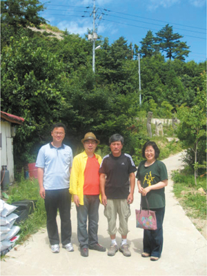
〈FIG 34〉 Photograph taken with Lee Deok-jun, a resident of Seokpo (third from the left)

When exactly in November can we see Dokdo Glory and at what latitude does the sun passes through Seokpo? How long can we see Dokdo Glory? Further, there would be a time at which the sun passes through exactly the same point in January or February when it moves north from the winter solstice. If the weather permits, we could see Dokdo Glory in January or February, too. We also examined the time of sunrise in November and in January-February when Ulleungdo, Dokdo, and the sun align in a straight line.
In the previous section, the sun’s location at sunrise when the altitude is 0 in Seokpo is indicated in 〈FIG 35〉 and 〈FIG 36〉 following the formula to calculate altitude and azimuth. The azimuth between Seokpo and Dokdo is 110° 33′37″.1519 (based on true north 0°)[note 154] Based on true south as 0 degrees, the figure was indicated with the sun’s location in November and January at sunrise. We determined the exact time that the location of Dokdo and the sun correspond. Dokdo Glory can be seen in November and in January-February, while the “Golden Sunrise” in which Ulleungdo, Dokdo, and the sun align in a straight line can be expected on November 6-10 and February 1-5.
 〈FIG 35〉The Sun’s Location and Date during November Sunrise. It is estimated that Dokdo Glory may be seen between November 6 and November 10 in the early morning.  |
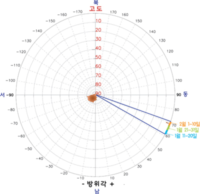 〈FIG 36〉The Sun’s Location and Dates at Sunrise between January and February This is indicated in a figure from mid-January to early February. To be precise, Dokdo Glory can be witnessed at sunrise between February 1 and February 5.  |
〈FIG 37〉 Dokdo is visible from Ulleungdo’s Seokpo with Jukdo on the right and the sun on the left.(photo by Yuk Myeong-geun)

It is natural that Dokdo is visible from Ulleungdo. It is more clearly visible when cold, clean air moves from the northeast, sweeping the humid air away from the sea.
We found that at around the time of the winter solstice in November and early February that one can see the spectacular Dokdo Glory in which the sun rises near Dokdo so that one can witness both the island and sunrise at the same time. Sometimes one can also see the “Golden Sunrise” in which Ulleungdo, Dokdo, and the sun align in a straight line.
Let us now go on a trip to Ulleungdo to discover Dokdo on the sea!
- [note 149]
- Gotsindong, “If you dream, that means you are alive: You can see the Dokdo sunrise from Ulleungdo” (December 25. 2009), Refer to .
- [note 150]
- Min Yeong-gi, et. al (1991), Fundamentals of Astronomy, Hyeongseol Publishing, pp. 9-24.
- [note 151]
- Iqbal, Muhammad Iqbal (1983), An Introduction to Solar Radiation, Ontario, Canada: Academic Press.
- [note 152]
- The name of a village located at the northeastern tip of Ulleungdo (Cheonbu-ri, Buk-myeon). The latitude used here is based on the Seokpo Village shelter where one can find binoculars and a gazebo from which the view of Dokdo is most spectacular.
- [note 153]
- the walking trail in the forest between Seokpo in Buk-myeon and the observatory in Naesujeon, Ulleung-eup.
- [note 154]
- This is a calculation made by Jeong Jae-jun, who derived this figure by measuring the azimuth between Seokpo (Ulleungdo) and the peak of West Islet (Dokdo). According to this calculation, the distance between Ulleungdo’s Seokpo and Dokdo’s West Islet peak is 90.8 kilometers and the azimuth is 110° 33′37″.1519.
[note 149]
Gotsindong, “If you dream, that means you are alive: You can see the Dokdo sunrise from Ulleungdo” (December 25. 2009), Refer to
.
닫기
[note 150]
Min Yeong-gi, et. al (1991), Fundamentals of Astronomy, Hyeongseol Publishing, pp. 9-24.
닫기
[note 151]
Iqbal, Muhammad Iqbal (1983), An Introduction to Solar Radiation, Ontario, Canada: Academic Press.
닫기
[note 152]
The name of a village located at the northeastern tip of Ulleungdo (Cheonbu-ri, Buk-myeon). The latitude used here is based on the Seokpo Village shelter where one can find binoculars and a gazebo from which the view of Dokdo is most spectacular.
닫기
[note 153]
the walking trail in the forest between Seokpo in Buk-myeon and the observatory in Naesujeon, Ulleung-eup.
닫기
[note 154]
This is a calculation made by Jeong Jae-jun, who derived this figure by measuring the azimuth between Seokpo (Ulleungdo) and the peak of West Islet (Dokdo). According to this calculation, the distance between Ulleungdo’s Seokpo and Dokdo’s West Islet peak is 90.8 kilometers and the azimuth is 110° 33′37″.1519.
닫기


