


- Dokdo in the East Sea
- Controversies surrounding Dokdo
- Dokdo! It can be seen from Ulleungdo
Dokdo in the East Sea


Table of Contents Open Contents
- Dokdo! It can be seen from Ulleungdo
- Overview: Background and Significance of the Dokdo Visibility Study
- Historical Meaning of “Dokdo’s Visibility from Ulleungdo”
-
Dokdo’s Visibility from Ulleungdo: Implications in International Law
- Ⅰ. Reasons Japanese Scholars Denied Dokdo’s Visibility from Ulleungdo
- Ⅱ. “Visibility of Dokdo from Ulleungdo” and Discovery in International Law
- Ⅲ. Dokdo’s Visibility from Ulleungdo and the Concept of Geographical Contiguity
- Ⅳ. Historical and Geographical Integrity and Territorial Sovereignty
- V. The Legal and Historical Unity of Ulleungdo and Dokdo
- The Meteorological Neaning of Dokdo’s Visibility from Ulleungdo
- Postscript after constant monitoring
It is important to clearly define the relationship between the peninsula and Ulleungdo. That is because the perception of Dokdo and the exploitation of Dokdo cannot be understood without the continuous interest in the islet by the Ulleungdo residents. The popular perception of the distance to Dokdo in relation to Ulleungdo is the outcome of continuous contact by the island’s residents. This perception has encouraged people to learn more about the islands.
The fact that Ulleungdo is visible from the peninsula can be the foundation for forming a close relationship between the peninsula and Ulleungdo. The historical fact that the Silla kings sent expeditionary forces to the State of Usan and conquered the island in 512 (thirteenth year of King Jijeung) was possible precisely because Ulleungdo was close to the coast and clearly visible. The forming of the relationship between the peninsula and Ulleungdo goes back before the conquest of the State of Usan by Isabu as the island of Ulleungdo is visible from the peninsula and vice versa.
The oldest historical record on the distance to Ulleungdo is found in Memorabilia of the Three Kingdoms (circa 1281 or 1283) in the section on the State of Usan expedition, “two days in a westerly wind” (便風二日程). During the Joseon period, more detailed descriptions on how long it takes to get to Ulleungdo appeared. In a report dated the fifteenth day of the seventh month of 1438 (twentieth year of King Sejong) in The Annals of King Sejong, there is information that the military officers Nam Hoi and Jo Min returned from Mureungdo with 66 men and women captives and spoils. They reported that it took one and a half days after setting sail (發船一日一夜乃至). In a report dated the sixteenth day of the fourth month of 1457 (thirteenth year of King Sejo) in The Annals of King Sejo (Sejo sillok), Ryu Su-gang sent a memorial to the king that recommended establishing an administrative office in Ulleungdo. In this memorial, the distance to Ulleungdo was described in detail. The memorial stated, “With a westerly wind, it takes about 20 hours. With a breeze and rowing, it takes one full day. Even without a wind, one can reach the island in two days by rowing” (西風直吹 則丑時發船亥時到泊, 風 微用櫓 一晝一夜可到, 無風用櫓 亦二日一夜可到).

 According to Seongho saseol (1740) by Yi Ik, “Located in the middle of the East Sea, Ulleungdo is also called the State of Usan. It is located 700 to 800 ri off the coast. One can see three peaks of the island vaguely at high places in Gangneung and Samcheok.”
In Ulleungdo Inspection Journal by Lee Gyu-won, is the comment, “Here [at the Sogong lookout point] I can see Ulleungdo, and it seems the island is part of the mountain range that I am standing on.” This comment is in a report dated the second day of the seventh month of 1882. The comment shows that one can see Ulleungdo from the Sogong lookout point in early summer if the weather is clear.
It is of critical importance to understand the distance between Ulleungdo and Dokdo as the perception toward Dokdo and its exploitation by the residents of Ulleungdo are essentially determined by its physical distance. There are not many records indicating the distance between Ulleungdo and Dokdo. Nonetheless, the fact that there are records which mention the distance between the two islands can be important evidence that people living in Ulleungdo were fully aware of the presence of Dokdo in their everyday lives.
The reigns of King Sejong (r. 1418-1450) and King Seongjong (r, 1469-1494) were characterized by the Joseon government’s completion of its administrative institutions. At the same time, geographical gazetteers were compiled during this period, including “Geographical Records,” which was completed in 1432 and subsequently included in The Annals of King Sejong, and the history of the previous Goryeo period was printed. [note 027] Geography Gazetteer of the Eight Provinces, (1477, eighth year of King Seongjong); Reference Documents on the Eastern Country (Dongkuk munheon bigo, 1486; compiled in the seventeenth year of King Seongjong and revised in 1499, or the fifth year of Yeonsangun); History of Goryeo, (1451, first year of King Munjong); Essentials of Goryeo History, (1452, second year of King Munjong). Excluding Geography Gazetteer of the Eight Provinces, which is not extant today, and Essentials of Goryeo History, which was written as a chronology, all of these texts include geographical sections on Ulleungdo and Dokdo. The Annals of King Sejong Geographical Records and New and Expanded Complete Conspectus of the Territory of the Eastern Country (1530, or the twenty-fifth year of King Jungjong) mention the islands in the section on Uljin County, Gangwon-do, and the History of Goryeo Geographical Records refers to the islands in the section on Uljin County, Donggye. The fact that these texts compiled by the Joseon government include sections on Ulleungdo and Dokdo means that the Joseon or Goryeo governments had clear intentions to claim these islands as their own. This is very important in settling the current dispute surrounding Dokdo.
Nonetheless, the descriptions on Ulleungdo and Dokdo in the three geography texts differ slightly, which leads to confusion in interpretation. The descriptions of Ulleungdo and Dokdo in the three geographical texts are as follows:
In The Annals of King Sejong Geographical Records, the islands of Usan and Mureung are located straight east of Uljin County and one island is visible from the other on a clear day, as they are not far apart. The History of Goryeo Geographical Records adds that Ulleungdo is located straight east of Uljin County and that the two islands of Usan and Mureung are not far apart, and one can see the other island on a clear day. Again New and Expanded Complete Conspectus of the Territory of the Eastern Country states that Usando and Ulleungdo are located straight east of Uljin County and that some say the two islands were originally a single entity.
In summary, The Annals of King Sejong Geographical Records, the printing of which predates all other Korean geographical texts, clearly mentions the presence of the two islands of Usan and Mureung. In contrast, History of Goryeo Geographical Records, which was printed about 20 years later, notes the one island of Ulleungdo with a passing reference to a “theory” of two islands. New and Expanded Complete Conspectus of the Territory of the Eastern Country, which reproduced the text in Dongguk yeoji seungnam without modification, discusses the two islands of Usan and Mureung, and includes a reference to the theory of one island.
One question that may be raised here is why the presence of the two islands of Usan and Mureung clearly recognized in The Annals of King Sejong Geographical Records was written in History of Goryeo Geographical Records as one island with a weak reference to a two-island theory. This question may be answered by taking into account the fact that the History of Goryeo gazetteer described the geography during the Goryeo period. The reference to an island called Usando as well as to Ulleungdo reflects the perception that held sway during the Goryeo period.
From this, it is understood that the descriptions of Ulleungdo and Dokdo in the three geographical texts are not inconsistent. History of Goryeo Geographical Records forwards a one-island theory of Ulleungdo, with a passing reference to a two-island theory. That theory is then changed to the Usan-Mureung two-island theory in The Annals of King Sejong. The New and Expanded Complete Conspectus of the Territory of the Eastern Country then makes a brief reference to the one-island theory while faithfully reproducing the two-island theory in The Annals of King Sejong Geographical Records.
In the section on Uljin County, Gangwon-do, in The Annals of King Sejong Geographical Records, the text states, “The two islands of Usan and Mureung are located straight east of Uljin County.” It then states, “One can see one island from the other on a clear day.” This is a reflection of the perception of the Joseon court toward the two islands during the early Joseon period. History of Goryeo Geographical Records, although printed later than The Annals of King Sejong Geographical Records, is considered to reflect the geographical views of the Goryeo court. Its ambivalent description of the two islands was not included in The Annals of King Sejong Geographical Records as geographers had learned more about the islands.
The account that the islands of Usan and Mureung are located straight east of Uljin County survived into the reign of King Sejo (r. 1455-1468). As seen in the memorial from Ryu Su-gang, the proposal to establish an administrative unit in Usan and Mureung (1457, or the third year of King Sejo) reflects this perception at the time. Such an opinion continued into the reigns of King Seongjong and the Yeonsangun (r. 1494-1506).
Since the early fifteenth century, however, the central government had maintained the policy of forcefully settling the island residents in the mainland and punishing those in violation of this measure. As a result, the islands of Usan and Mureung gradually became uninhabited lands with people no longer settling there. Instead, people on the east coast, especially those residing in Hamgil-do (also called Hamgyeong-do) in the northwest during the reigns of King Sejong and King Seongjong, began believing that there are islands called Yodo and Sambongdo in the East Sea. Those two islands must have been Dokdo and Ulleungdo.
New and Expanded Complete Conspectus of the Territory of the Eastern Country, which reproduced the phrases about Usando and Ulleungdo from Complete Conspectus of the Territory of the Eastern Country (Dongguk yeoji seungnam) states in the section on Uljin County, Gangwon-do, “Two islands [Usan and Ulleung] lie straight east of Uljin County.” This is a faithful reproduction of the records in The Annals of King Sejong Geographical Records, but the 1530 gazetter added in a note, “Some people believe that Usan and Mureung were a single island originally”[note 028]In The Annals of King Sejong Geographical Records and History of Goryeo Geographical Records, in particular, the distance between Ulleungdo and Dokdo was indicated in sentences instead of in numbers. The phrases used to describe the distance between Ulleungdo and Dokdo were apt and precise.
The Annals of King Sejong Geographical Records and History of Goryeo Geographical Records note the distance between Ulleungdo and Dokdo as “visible on clear days,” in addition to the reference confirming their presence.
Although History of Goryeo Geographical Records states that the two islands may have been a single entity as a hypothetical theory, The Annals of King Sejong Geographical Records states this as a fact.
Today, the days when one can see Dokdo from Ulleungdo are not simply clear days, but must be clear days with no fog near Dokdo’s shores. The only island near Ulleungdo that can satisfy the condition that it be visible on clear days is Dokdo. Of the islands lying near Ulleungdo, Gwaneumdo is only 100 meters from Ulleungdo and Jukdo is about two kilometers away. As the two islands are very close to Ulleungdo, they are visible all year around except on exceptionally foggy days. As for Dokdo, however, it is far enough away to be seen only on days when there is no fog near its shores.
The phrase “The two islands are not far apart and one can see one island from the other on clear days” is the best description of the geographical relationship between Ulleungdo and Dokdo. Dokdo is visible from Ulleungdo, but it is neither close enough nor far away. That is because the two islands are linked closely by their visual proximity. The only islands that satisfy the conditions that “not far apart and one island is visible from the other on clear days” (二島相去不遠 風日淸明 則可望見) are Ulleungdo and Dokdo. For this reason, one can see that these are records based upon a firm grasp of geographical knowledge. The phrase that the two islands are not far apart and one can see one island from the other on clear days shows the geographical relationship between Ulleungdo and Dokdo, and can be treated as important evidence that Usando was indeed Dokdo.[note 029]The first text that expressed the distance between Ulleungdo and Dokdo in a numerical form was Historical Records of Ulleungdo, written by by Jang Han-sang in the late seventeenth century. Jang estimated that there would be about 300 ri between Ulleungdo and Dokdo while noting that Dokdo is visible from Ulleungdo. The following is a description by Jang after climbing Jung Peak in Ulleungdo.
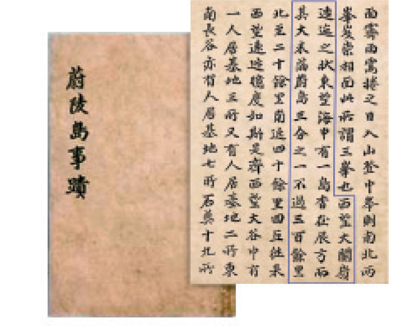
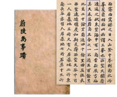 Jang described Dokdo thusly: “To the west, one can see the meandering Daegwan Pass, and there is an island in the middle of the sea to the east. Located in the east-southeast about 300 ri away, the island is one-third of Uldo in size.”
As also mentioned in this text, “The island vaguely visible in the east-southeast” is Dokdo, which can be seen from Ulleungdo on clear days. To this, Japanese scholars responded dismissively that the evidence is not strong enough and that this is not Dokdo but Jukdo. Given that Jang mentioned “a small island about five ri to the east of Ulleungdo,” which is none other than Jukdo, the far-distant island visible vaguely from Ulleungdo must be Dokdo.[note 031]Jang did not use the name “Usando” regarding the island vaguely visible from Ulleungdo to the east-southeast. But Park Se-dang, a contemporary of Jang, called the island Usando.
Park distinguished Ulleungdo from Usando clearly in name and also in his comments. He wrote, “Usando is low in height, thus it is visible only when the day is very clear or one climbs up to a peak.” This indicates that one can see Usando from Ulleungdo vividly on clear days or from higher points.
 These texts by Jang and Park show that the island visible from Ulleungdo is neither Jukdo nor Gwaneumdo, and that Dokdo is visible from Ulleungdo. Park wrote that Usando is not visible unless one climbs to a higher place or the weather is clear. From this, it is obvious that Usando is not Jukdo since the latter island lies very close to Ulleungdo. That is because the islands near Ulleungdo, such as Jukdo and Gwaneumdo, are easily visible from Ulleungdo all year around and even on cloudy days. The Usando mentioned by Park must then be located farther away than Jukdo or Gwaneumdo. The only candidate in the East Sea is today’s Dokdo. From this, one may easily conclude that the controversy regarding whether Usando is indeed Dokdo and whether Usando (that is, Dokdo) is visible from Ulleungdo is, without question, won by the Korean side. [note 033]The fact that Park Se-dang was able to describe Usando in detail demonstrates that people in his time were already aware of the island. Although it is difficult to say that all Koreans have been aware of Usando since ancient times, the idea of two islands lying side by side was firmly established by the middle of the Joseon period. Given that Usan and Ulleung (Mureung) were always mentioned together in historical texts, there is little doubt that there was another island called Usando other than Ulleungdo. But there is no historical record that corroborates this suggestion. The fact that there was a theory that treated Usan and Ulleung as a single island merely reflects the incomplete understanding of the islands, and not that people at the time were unaware of the presence of Usando. After the comments by Park Se-dang and Jang Han-sang were discovered, however, it became clear that views of Usando had grown firm during the middle part of the Joseon period. Given that both Jang and Park were contemporaries in the late seventeenth century and that the An Yong-bok incident occurred during the reign of King Sukjong, their records are based upon their own experiences. From such writings and events it became evident that Usando was indeed Dokdo. Although with qualifications that the weather must be clear or one must climb to a high point, the fact that Dokdo is visible is undoubtedly evidence favorable to Korea.
The historical records confirming the visibility of Dokdo from Ulleungdo are based on practical knowledge of Ulleungdo and Dokdo. These islands form a single geographical space based upon the knowledge of being visible from the other. The two islands are linked by an ocean current, and thus fishermen from Ulleungdo sailed near Dokdo to fish. [note 034] The geographical location that permitted one to see Dokdo and the current that flows from the South Sea to Ulleungdo enabled people on the east coast take advantage of these favorable conditions. The experiences of sailing and fishing encouraged people to be more aware of the island near Ulleungdo.
The fact that Ulleungdo is visible from the peninsula can be the foundation for forming a close relationship between the peninsula and Ulleungdo. The historical fact that the Silla kings sent expeditionary forces to the State of Usan and conquered the island in 512 (thirteenth year of King Jijeung) was possible precisely because Ulleungdo was close to the coast and clearly visible. The forming of the relationship between the peninsula and Ulleungdo goes back before the conquest of the State of Usan by Isabu as the island of Ulleungdo is visible from the peninsula and vice versa.
The oldest historical record on the distance to Ulleungdo is found in Memorabilia of the Three Kingdoms (circa 1281 or 1283) in the section on the State of Usan expedition, “two days in a westerly wind” (便風二日程). During the Joseon period, more detailed descriptions on how long it takes to get to Ulleungdo appeared. In a report dated the fifteenth day of the seventh month of 1438 (twentieth year of King Sejong) in The Annals of King Sejong, there is information that the military officers Nam Hoi and Jo Min returned from Mureungdo with 66 men and women captives and spoils. They reported that it took one and a half days after setting sail (發船一日一夜乃至). In a report dated the sixteenth day of the fourth month of 1457 (thirteenth year of King Sejo) in The Annals of King Sejo (Sejo sillok), Ryu Su-gang sent a memorial to the king that recommended establishing an administrative office in Ulleungdo. In this memorial, the distance to Ulleungdo was described in detail. The memorial stated, “With a westerly wind, it takes about 20 hours. With a breeze and rowing, it takes one full day. Even without a wind, one can reach the island in two days by rowing” (西風直吹 則丑時發船亥時到泊, 風 微用櫓 一晝一夜可到, 無風用櫓 亦二日一夜可到).
〈FIG 3〉
Seongho saseol by Lee Ik (1681-1763) is a compilation of this Neo-Confucian scholar’s conversations with his students. It contains valuable information on Korea’s politics, society, economy, geography, language, and history from ancient times to the early eighteenth century, with occasional comments by the author.

In Ulleungdo Inspection Journal by Lee Gyu-won, is the comment, “Here [at the Sogong lookout point] I can see Ulleungdo, and it seems the island is part of the mountain range that I am standing on.” This comment is in a report dated the second day of the seventh month of 1882. The comment shows that one can see Ulleungdo from the Sogong lookout point in early summer if the weather is clear.
It is of critical importance to understand the distance between Ulleungdo and Dokdo as the perception toward Dokdo and its exploitation by the residents of Ulleungdo are essentially determined by its physical distance. There are not many records indicating the distance between Ulleungdo and Dokdo. Nonetheless, the fact that there are records which mention the distance between the two islands can be important evidence that people living in Ulleungdo were fully aware of the presence of Dokdo in their everyday lives.
The reigns of King Sejong (r. 1418-1450) and King Seongjong (r, 1469-1494) were characterized by the Joseon government’s completion of its administrative institutions. At the same time, geographical gazetteers were compiled during this period, including “Geographical Records,” which was completed in 1432 and subsequently included in The Annals of King Sejong, and the history of the previous Goryeo period was printed. [note 027] Geography Gazetteer of the Eight Provinces, (1477, eighth year of King Seongjong); Reference Documents on the Eastern Country (Dongkuk munheon bigo, 1486; compiled in the seventeenth year of King Seongjong and revised in 1499, or the fifth year of Yeonsangun); History of Goryeo, (1451, first year of King Munjong); Essentials of Goryeo History, (1452, second year of King Munjong). Excluding Geography Gazetteer of the Eight Provinces, which is not extant today, and Essentials of Goryeo History, which was written as a chronology, all of these texts include geographical sections on Ulleungdo and Dokdo. The Annals of King Sejong Geographical Records and New and Expanded Complete Conspectus of the Territory of the Eastern Country (1530, or the twenty-fifth year of King Jungjong) mention the islands in the section on Uljin County, Gangwon-do, and the History of Goryeo Geographical Records refers to the islands in the section on Uljin County, Donggye. The fact that these texts compiled by the Joseon government include sections on Ulleungdo and Dokdo means that the Joseon or Goryeo governments had clear intentions to claim these islands as their own. This is very important in settling the current dispute surrounding Dokdo.
Nonetheless, the descriptions on Ulleungdo and Dokdo in the three geography texts differ slightly, which leads to confusion in interpretation. The descriptions of Ulleungdo and Dokdo in the three geographical texts are as follows:
-
- (1) The Annals of King Sejong Geographical Records
-
“The two islands, Usan and Mureung, are located straight east of the prefecture. As the two islands are not so far apart, one is visible from the other on a clear day.”
-
- (2) History of Goryeo Geographical Records
-
“There is an island called Ulleungdo. It is located straight east of the county. It was called the State of Usan during the Silla period. Alternatively, it was called Mureung or Ureung. The length and width are 100 ri …, or Usan and Mureung were two separate islands. As they are not so far apart, one island is visible from the other on a clear day.”
-
- (3) New and Expanded Complete Conspectus of the Territory of the Eastern Country
-
“Usando and Ulleungdo: Or they are called Mureung or Usan. The two islands are located straight east of the county. … Some say that Usan and Ulleung were a single island.”
In summary, The Annals of King Sejong Geographical Records, the printing of which predates all other Korean geographical texts, clearly mentions the presence of the two islands of Usan and Mureung. In contrast, History of Goryeo Geographical Records, which was printed about 20 years later, notes the one island of Ulleungdo with a passing reference to a “theory” of two islands. New and Expanded Complete Conspectus of the Territory of the Eastern Country, which reproduced the text in Dongguk yeoji seungnam without modification, discusses the two islands of Usan and Mureung, and includes a reference to the theory of one island.
One question that may be raised here is why the presence of the two islands of Usan and Mureung clearly recognized in The Annals of King Sejong Geographical Records was written in History of Goryeo Geographical Records as one island with a weak reference to a two-island theory. This question may be answered by taking into account the fact that the History of Goryeo gazetteer described the geography during the Goryeo period. The reference to an island called Usando as well as to Ulleungdo reflects the perception that held sway during the Goryeo period.
From this, it is understood that the descriptions of Ulleungdo and Dokdo in the three geographical texts are not inconsistent. History of Goryeo Geographical Records forwards a one-island theory of Ulleungdo, with a passing reference to a two-island theory. That theory is then changed to the Usan-Mureung two-island theory in The Annals of King Sejong. The New and Expanded Complete Conspectus of the Territory of the Eastern Country then makes a brief reference to the one-island theory while faithfully reproducing the two-island theory in The Annals of King Sejong Geographical Records.
In the section on Uljin County, Gangwon-do, in The Annals of King Sejong Geographical Records, the text states, “The two islands of Usan and Mureung are located straight east of Uljin County.” It then states, “One can see one island from the other on a clear day.” This is a reflection of the perception of the Joseon court toward the two islands during the early Joseon period. History of Goryeo Geographical Records, although printed later than The Annals of King Sejong Geographical Records, is considered to reflect the geographical views of the Goryeo court. Its ambivalent description of the two islands was not included in The Annals of King Sejong Geographical Records as geographers had learned more about the islands.
The account that the islands of Usan and Mureung are located straight east of Uljin County survived into the reign of King Sejo (r. 1455-1468). As seen in the memorial from Ryu Su-gang, the proposal to establish an administrative unit in Usan and Mureung (1457, or the third year of King Sejo) reflects this perception at the time. Such an opinion continued into the reigns of King Seongjong and the Yeonsangun (r. 1494-1506).
Since the early fifteenth century, however, the central government had maintained the policy of forcefully settling the island residents in the mainland and punishing those in violation of this measure. As a result, the islands of Usan and Mureung gradually became uninhabited lands with people no longer settling there. Instead, people on the east coast, especially those residing in Hamgil-do (also called Hamgyeong-do) in the northwest during the reigns of King Sejong and King Seongjong, began believing that there are islands called Yodo and Sambongdo in the East Sea. Those two islands must have been Dokdo and Ulleungdo.
New and Expanded Complete Conspectus of the Territory of the Eastern Country, which reproduced the phrases about Usando and Ulleungdo from Complete Conspectus of the Territory of the Eastern Country (Dongguk yeoji seungnam) states in the section on Uljin County, Gangwon-do, “Two islands [Usan and Ulleung] lie straight east of Uljin County.” This is a faithful reproduction of the records in The Annals of King Sejong Geographical Records, but the 1530 gazetter added in a note, “Some people believe that Usan and Mureung were a single island originally”[note 028]In The Annals of King Sejong Geographical Records and History of Goryeo Geographical Records, in particular, the distance between Ulleungdo and Dokdo was indicated in sentences instead of in numbers. The phrases used to describe the distance between Ulleungdo and Dokdo were apt and precise.
(1) Visible on clear days
The Annals of King Sejong Geographical Records and History of Goryeo Geographical Records note the distance between Ulleungdo and Dokdo as “visible on clear days,” in addition to the reference confirming their presence.
-
“The two islands of Usan and Mureung are located straight east of the county.
(The islands are not far apart from each other and one can see one island from the other on a clear day.)”
-
“Some say that Usan and Mureung originally was a single island. They are not far apart from each other and one can see one island from the other on a clear day.”
Today, the days when one can see Dokdo from Ulleungdo are not simply clear days, but must be clear days with no fog near Dokdo’s shores. The only island near Ulleungdo that can satisfy the condition that it be visible on clear days is Dokdo. Of the islands lying near Ulleungdo, Gwaneumdo is only 100 meters from Ulleungdo and Jukdo is about two kilometers away. As the two islands are very close to Ulleungdo, they are visible all year around except on exceptionally foggy days. As for Dokdo, however, it is far enough away to be seen only on days when there is no fog near its shores.
(2) The two islands are not far apart, and a person can see one island from the other on clear days.
The phrase “The two islands are not far apart and one can see one island from the other on clear days” is the best description of the geographical relationship between Ulleungdo and Dokdo. Dokdo is visible from Ulleungdo, but it is neither close enough nor far away. That is because the two islands are linked closely by their visual proximity. The only islands that satisfy the conditions that “not far apart and one island is visible from the other on clear days” (二島相去不遠 風日淸明 則可望見) are Ulleungdo and Dokdo. For this reason, one can see that these are records based upon a firm grasp of geographical knowledge. The phrase that the two islands are not far apart and one can see one island from the other on clear days shows the geographical relationship between Ulleungdo and Dokdo, and can be treated as important evidence that Usando was indeed Dokdo.[note 029]The first text that expressed the distance between Ulleungdo and Dokdo in a numerical form was Historical Records of Ulleungdo, written by by Jang Han-sang in the late seventeenth century. Jang estimated that there would be about 300 ri between Ulleungdo and Dokdo while noting that Dokdo is visible from Ulleungdo. The following is a description by Jang after climbing Jung Peak in Ulleungdo.
- There is a small island about five ri to the east which is not so big or high, and with bamboo growing on one side. On a day immediately following rain or fog, one can see two high peaks in front from Jung Peak. These are called Sambong. To the west, one can see the meandering Daegwan Pass. And there is an island in the middle of the sea to the east. Located to the east-southeast about 300 ri away, the island is one-third of Uldo in size.[note 030]
〈FIG 4〉 Ulleungdo sajeok
As also mentioned in this text, “The island vaguely visible in the east-southeast” is Dokdo, which can be seen from Ulleungdo on clear days. To this, Japanese scholars responded dismissively that the evidence is not strong enough and that this is not Dokdo but Jukdo. Given that Jang mentioned “a small island about five ri to the east of Ulleungdo,” which is none other than Jukdo, the far-distant island visible vaguely from Ulleungdo must be Dokdo.[note 031]Jang did not use the name “Usando” regarding the island vaguely visible from Ulleungdo to the east-southeast. But Park Se-dang, a contemporary of Jang, called the island Usando.
- "The two islands are not so far apart and one can reach the island shortly from the other with a favorable wind. Usando is low in height, thus it is visible only when the day is very clear or one climbs up to a peak. Ulleungdo is slightly higher [than Usando].”[note 032]
〈FIG 5〉 Gwaneum-do (Left) and Jukdo (Right)

The historical records confirming the visibility of Dokdo from Ulleungdo are based on practical knowledge of Ulleungdo and Dokdo. These islands form a single geographical space based upon the knowledge of being visible from the other. The two islands are linked by an ocean current, and thus fishermen from Ulleungdo sailed near Dokdo to fish. [note 034] The geographical location that permitted one to see Dokdo and the current that flows from the South Sea to Ulleungdo enabled people on the east coast take advantage of these favorable conditions. The experiences of sailing and fishing encouraged people to be more aware of the island near Ulleungdo.
- [note 027]
- The Annals of King Sejong was printed in 1454 (second year of King Danjong), but the gazetteer section was completed in 1432 (the fourteenth year of King Sejong), with all of the descriptions in this text using 1430 as the base year. Jeong Du-hwi (1976), “Compilation of Geographical Gazetteers during the Early Joseon Period,” Yeoksa hakbo, pp. 69-74.
- [note 028]
- Song Byeong-gi (2004), Selected Writings on Dokdo Territorial Claims, Hallym University Publishing, pp. 204-208.
- [note 029]
- Baek In-gi and Sim Mun-bo (2006), op. cit., pp. 44-47.
- [note 030]
- Jang Han-sang (1694), 『鬱陵島事蹟』: “東方五里許 有一小島 不甚高大 海長竹叢生於一面 霽雨 馬捲之日 入山登中峰 則南北兩峯 岌崇相面 此所謂三峰也 西望大關嶺逶之狀 東望海中 有一島 杳在辰方 而其大未滿蔚島三分之一 不過三百餘里.”
- [note 031]
- The fact that the vaguely visible island in Jang was not Jukdo is extensively discussed in Yu Mi-rim, op. cit., pp. 91-92.
- [note 032]
- Park Se-dang, Ulleungdo: “盖二島去此不甚遠一飄風可至于山島勢卑不因海極淸朗不登最高頂 則不可見鬱陵 稍崚”
- [note 033]
- Yoo, op. cit., pp. 93-94.
- [note 034]
- Baek In-gi and Sim Mun-bo (2006), op. cit., p. 104.
[note 027]
The Annals of King Sejong was printed in 1454 (second year of King Danjong), but the gazetteer section was completed in 1432 (the fourteenth year of King Sejong), with all of the descriptions in this text using 1430 as the base year. Jeong Du-hwi (1976), “Compilation of Geographical Gazetteers during the Early Joseon Period,” Yeoksa hakbo, pp. 69-74.
닫기
[note 028]
Song Byeong-gi (2004), Selected Writings on Dokdo Territorial Claims, Hallym University Publishing, pp. 204-208.
닫기
[note 029]
Baek In-gi and Sim Mun-bo (2006), op. cit., pp. 44-47.
닫기
[note 030]
Jang Han-sang (1694), 『鬱陵島事蹟』: “東方五里許 有一小島 不甚高大 海長竹叢生於一面 霽雨 馬捲之日 入山登中峰 則南北兩峯 岌崇相面 此所謂三峰也 西望大關嶺逶之狀 東望海中 有一島 杳在辰方 而其大未滿蔚島三分之一 不過三百餘里.”
닫기
[note 031]
The fact that the vaguely visible island in Jang was not Jukdo is extensively discussed in Yu Mi-rim, op. cit., pp. 91-92.
닫기
[note 032]
Park Se-dang, Ulleungdo: “盖二島去此不甚遠一飄風可至于山島勢卑不因海極淸朗不登最高頂 則不可見鬱陵 稍崚”
닫기
[note 033]
Yoo, op. cit., pp. 93-94.
닫기
[note 034]
Baek In-gi and Sim Mun-bo (2006), op. cit., p. 104.
닫기


