- Dokdo in the East Sea
- Educational material
- Junior High School Version
Dokdo in the East Sea
Table of Contents Open Contents
- Dokdo: Korean Territory
- Dokdo: Keeper of the East Sea!
- Ulleungdo and Dokdo: We’re Siblings!
- Dokdo’s Been Korean Land Since the Three Kingdoms Period!
- Dokdo’s Been Korean Land in the Modern Era!
- Dokdo Appears Even on Old Maps!
- Mission: Protect Dokdo!
- Others Have Known, Too ... That Dokdo Is Korean Land!
- Dokdo Is Korean Land Even on Old Japanese Maps!
- Japan’s Claims to Dokdo Are False!
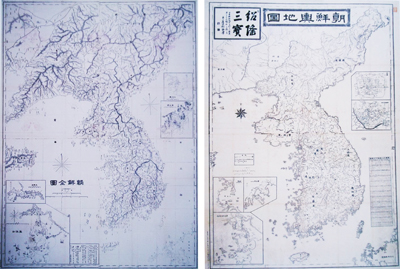
Enrichment: Japanese maps that show Dokdo as Korean territory[Teacher Notes]
Ⓐ “Complete Map of Joseon”
Department of the Army, 1876, 127.1×94.1cm
The map’s scope includes Joseon and the southwest Liaodong Peninsula. Ulleungdo and Dokdo are labeled as Takeshima and Matsushima, respectively. Dokdo is at the right edge of the image, indicating that effort was made to include the island in the map.
Ⓑ “Map of Joseon”
Shimizu Mitsunori, 1884, 105.1×77.1cm
This map illustrates the activities of the Gaehwa Youth during the Imo Incident and the Gapsin Coup. It was compiled from Kim Ok-gyun’s map of Joseon. Takeshima and Matsushima are the same color as Joseon’s Gangwon-do and are labeled as Joseon territory.
-
Summary
1. “Map of the Three Countries” (1785) - Ulleungdo, Dokdo, and Joseon are all in the same color, and the French-language version of this map was used as evidence during the French-American territorial disputes.
2. “Complete Geographical Map of the Japanese Coasts” (1821) – This map shows Sado Island and Tsushima Island, which are near Dokdo, but does not show Dokdo.
3. “Map of Joseon and the Coast of the East Sea” (1876) - Based on a Russian map, this map was composed by the Japanese Department of the Navy for military use.
4. “Complete Map of Korea” from True History of the Russo-Japanese War (1905) - This map also labeled Dokdo as Korean territory.
Teacher Notes
Korea has long had the right to exercise control over Ulleungdo and Dokdo. Korea’s claims are strengthened by presenting Japanese and world maps that include these islands as Korean territory.
닫기


