- Koguryo and Balhae
- Korea-China History Awareness
Koguryo and Balhae
Table of Contents Open Contents
- History in Dispute
- The Northeast Project: Intent and Contrivance
- China’s Claims and Korea’s Perspective
- The Northeast Project: Impact and Response
- Details of the Northeast Project and its Research Results
- Northeast Project Reference List
Mt. Baekdu Demarcation Stone
- ▶ Mt. Baekdu Demarcation Stone was originally located at Sobaek Mountain.
- ▶ Mt. Baekdu Demarcation Stone has been at the foot of Baekdu Mountain since its installation until 1931.

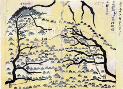
▲ Mt. Baekdu Demarcation Stone Map (1712, Preserved by Seoul National University) The creation of this map was ordered by Geuk-deung Mok, a Qing dynasty official, immediately after erecting the Mt. Baekdu Demarcation Stone. The responsible attendant was instructed to illustrate the tributaries (stream that flows into another body of water) near Baekdu Mountain, Yalu River, and Dooman River, and a copy of the map was provided to Joseon official Kwon Bak. The Demarcation Stone was erected at the foot of Baekdu Mountain and engraved with the phrase Gangwon-bi (literally " Headstone of River "). Sobaek Mountain is located southwest of the Demarcation Stone marked as a separate peak alongside Daegak Peak and Yeonji Peak.

The Demarcation Stone Displacement Theory was raised around the time of negotiations between Japan and the Qing dynasty regarding Jiando. Recently, this theory has been elaborated upon to include claims that the Demarcation stone had been moved four separate times. However, an inspection of old maps and records from the period quickly reveals the Demarcation Stone Displacement Theory to be a fallacy. Records by people who participated in the installation of the Mt. Baekdu Demarcation Stone and those who climbed Baekdu Mountain thereafter all are all consistent in the location of the stone.
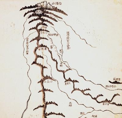
At the time, people who climbed Baekdu Mountain passed the Samjiyeon Lakes, Sobaek Mountain, then Yeonji Peak, and subsequently witnessed the Mt. Baekdu Demarcation Stone. Furthermore, the Mt. Baekdu Demarcation Stone Map, created at the time of installation, and various other old maps that depict Baekdu Mountain all place the stone in roughly the same location. Old maps place the Mt. Baekdu Demarcation Stone between Baekdu Mountain and Yeonji Peak with the word "watershed" inscribed nearby.

▲ Map of the Upper Dooman River This map was included in Namseon Choi's Baekdu Mountain Expedition Records (1927). The solid red lines indicate Namseon Choi's route. From the upper Dooman River moving east, the tributaries indicated on the map are Hongto, Seokeul, Hongdan, and Seodu.

Changbai Mountain Culture
The phrase "Changbai Mountain Culture" emerged as the importance of cultural enterprise was highlighted in the process of economic development in the northeastern region of China. Changbai Mountain Culture was introduced during the Changbai Mountain Culture Conference in the city of Baishan in 1994. Subsequently, the Changbai Mountain Culture Research Group was formed in 2000 under the supervision of Jilin Province to broaden the range of activities, and Changbai Mountain Culture was highlighted as a symbol of Northeast Asian culture. In 2008, the Changbai Mountain Culture Research Base was established by the Changbai Mountain Protection and Development Zone Management Committee and combined with Baekdu Mountain development and cultural research.
The framework for Changbai Mountain Culture was completed as awareness for its importance grew and research results accumulated. Changbai Mountain Culture was defined as a local culture jointly created by several ethnic groups in the Changbai Mountain regions, primarily of Chinese culture built on a foundation of Sushen and Yemaek tribal cultures. The main characteristic of Changbai Mountain Culture are: ① Material culture based on agriculture, fishing, and nomadism, ② Political culture based on military unity and chain of command, ③ Folk culture based on simplicity, naturalness, and proficiency in mounted archery, ④ Religious culture based on polytheistic shamanism and animism. The establishment of Changbai Mountain Culture was highlighted by using the Paleolithic culture of the Mt. Baekdu Mountain regions and Neolithic culture of the Liao River basin as the foundation of Changbai Mountain Culture. Although the importance of Manchurian tribal culture was featured, the dominant position of Chinese culture was emphasized through a fusion of multiple ethnic cultures.
Changbai Mountain Culture has revealed several glaring issues by including cultural elements of various ethnic groups from Manchuria and the Korean Peninsula and making Changbai Mountain Culture the main component in the foundation of Chinese culture through the application of the Unified Multi-Ethnic Country theory. As the slogan "Awaken the people of the Northeast to promote Northeast" suggests, Changbai Mountain Culture changed the people of China's northeastern region to the subject of economic development, and they are being utilized as a rich resource for tourism and cultural enterprise.
Mt. Baekdu Demarcation Stone
Mt. Baekdu Demarcation Stone was erected southeast of Baekdu Mountain after a survey of the Yalu and Dooman Rivers and their surrounding areas by Joseon and Qing dynasty assessors in 1712. The engraving on the marker read "Yalu River is the boundary to the west, and Dooman River is the boundary to the east." Exactly to which waterway the name Dooman River indicated was a point of contention. The Demarcation Stone disappeared in 1931, and currently only the base remains.
닫기


