- Dokdo in the East Sea
- Educational material
- High School Version
Dokdo in the East Sea
Table of Contents Open Contents
3. Dokdo in Maps
-
- Objectives
-
Identify Ulleungdo and Usando in historical Korean maps.
Explain the difference between Japanese maps with and without Usando.
-
- Critical Thinking
-
The first appearance of Usando (Dokdo) in historical Korean maps is in the late fifteenth century. However, the locations of the islands are switched, and Usando is located to the west of Ulleungdo. How should this error be interpreted?
The First Korean Map to Feature Usando (Dokdo)
Numerous historical Korean maps show Usando. However, Usando’s location in early Joseon period maps is inaccurate. Although aware of the existence of both islands, the cartographers of the time were not able to accurately portray their geospatial relationship.
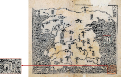
The first map from the early Joseon period to show Usando was the “Map of the Eight Provinces” in New and Expanded Complete Conspectus of the Territory of the Eastern Country (1531). First compiled in 1481, both Ulleungdo and Usando are depicted in the East Sea. Although Usando is correctly portrayed as being smaller than Ulleungdo, the locations of the islands are switched.
Although the location is not accurate, the map is clear evidence that people were aware of the existence of two distinct islands.
As the geographical information improved over time, Usando was eventually depicted in the correct shape and location.
Created by Jeong Sang-gi during the reign of King Yeongjo in the late Joseon period, the “Map of the Eastern Country” shows Usando in an accurate location. Most extant maps are similar to this one.
Usando is also illustrated in the “Yeo Map” which is a part of the “Atlas of Joseon” (late eighteenth century). Although the author is unknown, islands in the East Sea are illustrated with vibrant colors, and Usando’s size and location are accurate. In the “Complete Nautical Map” from the mid-nineteenth century, Usando is located to the east of Ulleungdo and portrayed as a set of islands.
As such, Korean maps since the eighteenth century have illustrated Usando to be east, northeast, or southeast of Ulleungdo, and Dokdo’s location became increasingly more accurate. Most maps of the time can be considered survey maps, and the accurate portrayal of Ulleungdo and Dokdo’s location, shape, and size signify the country’s territorial awareness.
-
- Activity 1
-
Find the historical Korean map that features Usando (Dokdo).
Dokdo in Historical Japanese Maps
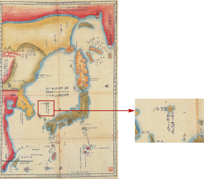
As Dokdo was considered to be Korean territory, if Japan’s maps of Korea are excluded, Ulleungdo and Dokdo are not illustrated on historical Japanese maps. Most eighteenth century Japanese maps illustrate Ulleungdo and Dokdo outside of the Japanese territorial boundaries. Several maps portray Ulleungdo and Dokdo close to the Joseon mainland, and the islands and the mainland are illustrated in the same color.
· Revised Complete Map of Japan’s Land and Roads(改正日本輿地路程全圖)」(1779)

Revised Complete Map of Japan’s Land and RoadsLooking at Goryeo (Joseon) from Takeshima is similar to looking at Inshū (Oki Islands) from Onshū (Matsue domain).

· “The Great Three Kingdoms Map” (1785)
Created by the Japanese military scholar named Hayashi Shihei in 1785, this is one of five maps included in “Map of the Three Countries.” Takeshima (Ulleungdo) and an island to its right not identified are colored in yellow along with the Joseon mainland. This map even includes the words “Joseon land” next to the islands. Japan is colored in green.
-
- Activity 2
-
Analyze the significance of Ulleungdo and Dokdo being illustrated in the same color as the Joseon mainland in historical Japanese maps.
Dokdo in Historical Western Maps
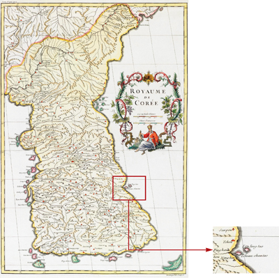
Based on the work of missionaries to China, Westerners also created maps of Joseon. The first complete map of Joseon to be created by a Westerner is “Royaume de Corée” by the French royal geographer Jean Baptiste Bourguignon d’Anville. This map was created using the “Atlas of the Chinese Empire” as the basis. Ulleungdo is labeled Fan-ling-tao, and Usando is labeled Tchian-chan-tao. D’Anville misread Ulleungdo as “Banreungdo” and Usando (Dokdo) as “Chunsando” and wrote the Chinese pronunciations. Nevertheless, the two islands are shown as Joseon territory.
“Complete Map of Joseon” was compiled by a Korean priest in China named Kim Dae-geon (1846). A French consul in China composed a Romanized copy of this map, and it shows “Oulengto” (Ulleungdo) and “Ousan” (Usan/Dokdo) illustrated in the East Sea. This is the first map of Joseon compiled by a Westerner to show the name “Usan” for Dokdo.
-
- Activity 3
-
The following names have been used for Ulleungdo and Dokdo in Western maps. Write the correct corresponding names.
· Fan-ling-tao →
· Tchian-chan-tao →
· Oulengto →
· Ousan →
Records on Observations on Oki
Geographical records about the Oki Islands (1667). It is the first Japanese historical record to contain references to Dokdo. It describes the Oki Islands as Japan’s northwestern boundary.
닫기


