- Dokdo in the East Sea
- Dokdo in History
- Dokdo is Korean Territory
Dokdo in the East Sea
Table of Contents Open Contents
- Dokdo is Korean Territory
-
Ⅰ. Roots of Territorial Claims to Dokdo
- 1. Korean Territorial Claims Proven by Japanese Historical Sources
- 2. Korean Territorial Claims Proven by Korean Historical Sources
- 3. The Japanese government’s claim that it established territorial rights over Dokdo in the mid-seventeenth century is a fabrication.
- 4. The Highest Decision-making Office in Japan’s Meiji Government Decides that Dokdo and Ulleung are Part of Korean Territory
- Ⅱ. On the declaration of territorial rights over Dokdo by the Korean government and the illegality of the island’s annexation in 1905 to Shimane Prefecture
- Ⅲ. Korea’s Territorial Rights to Dokdo Seen from Measures Taken by the Allied Powers after World War II
- Ⅳ. Korea’s Territorial Claims on Dokdo after the San Francisco Peace Treaty
- Ⅴ. Korea’s Territorial Rights over Dokdo Seen from International Law
1. Korean Territorial Claims Proven by Japanese Historical Sources

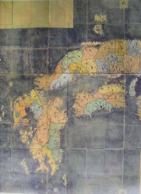
“Bakufu-sen Keichō Nihon chizu” (幕府撰慶長日本地圖): western Japan (1640)The Edo shogunate ordered that this map be compiled. It shows the Oki Islands marked as the northwestern-most territory. The other four maps commissioned by the government show the same territory. The Edo shogunate considered Dokdo as part of Joseon territory.

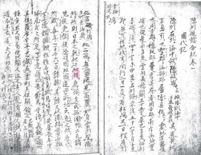
In “Records on Observations on Oki” is written, “Northwest of Japan, we make this land to be the boundary,” meaning that the Oki Islands were the northwestern territorial limit of Japan. In addition, the Edo shogunate published Japanese maps in five editions. Of these, the first four maps were based on regional maps and the fifth one was compiled from surveys conducted by Inō Tadataka under the order of the shogunate. These five government-commissioned maps compiled by the Edo shogunate excluded Dokdo from the territory of Japan.

A chapter in Kokutai ki entitled “Records on Observations on Oki”Legend: “If you proceed northwest you will reach Matsushima (松島; that is, Dokdo) in two days and one night. And you will reach Takeshima (竹島; that is, Ulleungdo) in one more day. These two places are uninhabited islands. From there you can see Joseon, just as you can see Oki from Unshū, which is part of Matsue domain.” Thus, the land (that is, the Oki Islands) northwest of Honshu Island is the territorial boundary.


