- Dokdo in the East Sea
- Controversies surrounding Dokdo
- Ten Truths about Dokdo Not Known in Japan
Dokdo in the East Sea
Table of Contents Open Contents
- Ten Truths about Dokdo Not Known in Japan
- 1. Japan claims it has long recognized the existence of Dokdo.
- 2. Japan claims there is no evidence that Korea recognized the existence of Dokdo in the past
- 3. Japan claims that it established its sovereignty over Dokdo in the mid-seventeenth century.
- 4. Japan claims that it banned passage to Ulleungdo in the late seventeenth century, but did not ban passage to Dokdo
- 5. Japan claims that Ahn Yong-bok’s statement is not reliable
- 6. Japan claims Japan reaffirmed its intention to claim sovereignty over Dokdo by incorporating the island into Shimane Prefecture in 1905
- 7. Japan claims that while drafting the San Francisco Peace Treaty the United States suggested that Dokdo is under the jurisdiction of Japan
- 8. Japan claims the designation of Dokdo as a bombing range for military practice for the United States Forces in Japan shows that Dokdo was treated as part of Japan’s territory
- 9. Japan claims that the Republic of Korea is illegally occupying Dokdo
- 10. Japan claims although Japan proposed to the Republic of Korea to refer this dispute over Dokdo to the International Court of Justice, the Republic of Korea rejects doing so.
Japan claims there is no evidence that Korea recognized the existence of Dokdo in the past
Korea claims that Usando is the current island of Dokdo. However, Usando is either the same island as Ulleungdo or non-existent.
Japan’s claims is not true because...
Korea’s clear recognition of Dokdo is proven by ancient documents and maps.
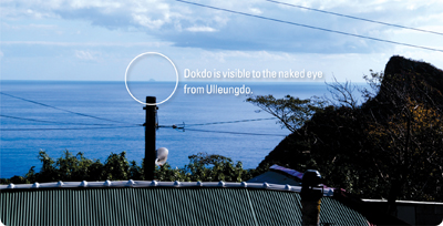
On fine days, Dokdo is visible to the naked eye from Ulleungdo. (See Material 4.) Dokdo has historically been recognized as part of Ulleungdo due to this geographical characteristic. The Geographical Appendix to the Veritable Records of King Sejong (Sejong sillok jiriji, 1454) states, “Usan [that is, Dokdo] and Mureung [that is, Ulleungdo] are located in the middle of the sea, due east of this county. The two islands are visible from each other on fine days, as they are not far apart. The island was called Usan-guk in the Silla period, and it is also known as Ulleungdo.” This clarifies that Ulleungdo is visible from Dokdo, and Usando belonged to Usan-guk.
Numerous historical documents issued by the Korean government, including The Newly Enlarged Geographical Survey of Korea (Sinjeung Dongguk yeoji seungnam, 1531), Reference Compilation of Materials on Korea (Dongguk munheon bigo, 1770), The Book of Ten Thousand Techniques of Governance (Mangi yoram, 1808), and Revised and Enlarged Edition of the Reference Compilation of Documents on Korea (Jeungbo Munheon bigo, 1908), record that Usando is the same as Dokdo.
In particular, descriptions in documents such as “Considering Maps” in Reference Compilation of Materials on Korea (“Yeojigo,” in Dongguk munheon bigo) which state that both Ulleung (Ulleungdo) and Usan (Dokdo) are territory of Usan-guk, and Usan (Dokdo) is what Japan calls Matsushima, clearly indicate that Usando is Dokdo.
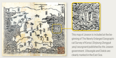
“The Map of the Eight Provinces of Korea” (Paldo chongdo), in The Newly Enlarged Geography of Korea (Sinjeung Dongguk yeoji seungnam) has the two islands of Ulleungdo and Usando [Dokdo] in the East Sea (see Material 5). The locations are not precise, but the presence of the two islands means that their existence had been clearly recognized at the time when the map was drawn. And all the maps produced after the eighteenth century, including “Map of Korea” (Dongguk jido), place Usando east of Ulleungdo, showing that the location and formation of Dokdo had also become more precise.
-
- MATERIAL 4. Dokdo Seen from Ulleungdo
-
- MATERIAL 5. “The Map of the Eight Provinces of Korea (Paldo chongdo)”


